
Scuppernong River Preserve

LOCATION:
Coastal Plain
Tyrrell and Washington Counties
SIZE IN ACRES:
653
INVOLVEMENT IN ACRES:
NA

Hooded mergansers (© Ken Taylor) |
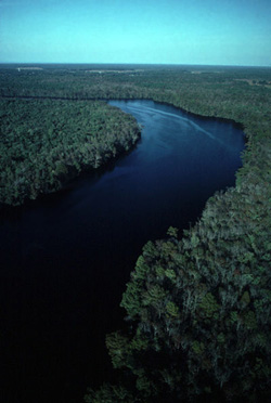
The Scuppernong River (© Merrill Lynch) |
TOPOGRAPHICAL MAP:
Columbia East, Columbia West, Creswell, Creswell Southeast
Topographical maps are available by contacting:
NC Geographical Survey.
1612 Mail Service Center
Raleigh, NC 27699-1612.
(919) 715-9718
www.geology.enr.state.nc.us/
ACTIVITIES & AMENITIES:
Birding / Fishing / Small Boats / Canoeing
OWNERSHIP & ACCESS:
The Scuppernong River is best explored by small boat on day trips, since the land along the river is privately owned. If you spend a weekend exploring this remote natural area, camping is available at nearby Pettigrew State Park and Lake Phelps.
SITE INFORMATION:
The Scuppernong is a blackwater river that flows through Tyrrell and Washington Counties into the Albemarle Sound. This free-flowing river is a great place to canoe, birdwatch, and fish. The river's broad floodplain is comprised of diverse wetland forest communities, including extensive swamp forests of bald cypress, pond pine, sweetgum, sweet bay, and significant stands of rare Atlantic white cedar.
The river's floodplain provides an important wildlife corridor between Alligator River and Pocosin Lakes National Wildlife Refuges. Black bear, bobcat, and river otter are common in this area, with the deep organic soils and thick forest providing an almost impenetrable protective barrier on the shoreline.
CONSERVATION HIGHLIGHTS:
Since 1989, the North Carolina Chapter has protected five tracts on the river through separate purchases and donations.
DIRECTIONS:
The Scuppernong is included in the Albemarle Region Canoe Trail system. There is a public boat landing south of the town of Creswell on Main Street.
The Visitor Center in Columbia offers canoe access and a 3/4 mile boardwalk through a bottomland swamp bordering the river.
Pettigrew State Park is located nine miles south of Creswell off of US 64 on SR 1166.
Pettigrew State Park
2252 Lake Shore Drive
Creswell, NC 27928
(252) 797-4475
|

