Chile’s land of ice-blue lakes


The Carretera Austral could be one of the most spectacular and challenging cycle tours in the world. It is made of endless stretches of empty dirt roads surrounded by forests, mountains, glaciers and lakes, with scenic villages, free campsites and hot springs along the way. The route is so remote that some days you might only see a jinete (horseman) trot by with his band of dogs. But the journey is not unachievable – all you need is a sturdy bike, a knack for light packing and a sense of adventure to make this the cycle tour of a lifetime.
Lie of the land
The Carretera Austral stretches for 1,240km through rural Chilean Patagonia, from the seaside town of Puerto Montt in the north to the village of Villa O’Higgins in the south. Started in 1976 but not completed until 2000 due to the dangerous and difficult terrain, the road was built by some 10,000 men from the Chilean Army’s Engineering Command, many of whom lost their lives; markers and shrines dot the road.
Before the carretera (highway), the only road access to this remote part of Patagonia involved travelling through neighbouring Argentina, meaning that the region retains a spectacularly rugged, unspoiled environment and a strong identity. Its people are tough, resourceful and proud of their regional identity: men often still wear traditional ponchos, sheepskin riding chaps and the Patagonian black beret.
However, this may be about to change. Two separate hydroelectric dam projects that together comprise seven dams, and a 2,300km-long transmission line to carry energy to Chile’s centre and north are on the cards. They may be completed as soon as 2025. There has been vociferous local and national debate against them, with the anti-dams campaign, Patagonia sin Represas (Patagonia without Dams) emphasising irreversible social and environmental damage. Whether the present dam projects go ahead or not, there is little doubt the area could see these kinds of developments in the future.
For riders on the Carretera Austral, this could mean years of major roadworks and heavy dam-building machinery on the route. It could also mean clearing of forest and blasting of mountainsides to rig high tension power lines in once-picturesque environments. For one stretch, the cycling route will run alongside a stagnant hydroelectric dam instead of the spectacularly torrential ice-blue waters of the glacier-fed Rio Baker, Chile’s most strongly flowing river. The road will bear more traffic, the area more people (at least 6,000 workers will be needed for the dam building at its peak) and this part of Patagonia will certainly lose its remote, lost-in-time feel.
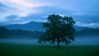
Nature all around
In its current northern incarnation, the carretera ploughs through deep-green native forests of alerce, tepú, Andean cypress, lengua and coigüe. Wildlife includes endangered deer species such as the elegant huemul and the diminutive pudu, the world's smallest at only 35 to 45cm tall. In the forests, rarely seen pumas roam. Condors soar over the mountaintops, woodpecker tapping echoes among towering trees, and hummingbirds flit between fuchsias and the gigantic leaves of gunnera (Chilean rhubarb) which grow up to 2m tall.
The rawness of living with Patagonian nature is clear: the town of Chaiten, a few days cycling (and at least three ferry rides) out of Puerto Montt was all but buried by volcanic ash in 2008. It is now being rebuilt by a few determined returnees.
As the road heads south, the forest transitions from the Valdivian rainforests into the Magellanic forests, which are home to deciduous Antarctic beech. At the southern end of the carretera, patches of Patagonian tundra begin: wide, grassy valleys and shrubby plateaux, interspersed with marshlands and lakes.
The Carretera Austral and its branch roads pass through two national parks, the volcano-dominated Hornopirén National Park and Parque Nacional Quelat, with its spectacular hanging glacier from which chunks of ice regularly thunder down into the baby-blue lake below. There are also hot springs along the route: at fjordside Puyuhuapi near Quelat, you can soak in the steaming pools, watching dolphins cruise by and hummingbirds sip nectar; while the spectacular, fjorded and thickly forested privately owned Pumalín Park allows access to several hot springs.
Then the road plunges into a land of ice-blue lakes, such as Lago General Carrera with its astounding marble caves and pale blue ribbons of rivers. The rivers here drain the Southern Patagonian Icefield, the largest in the southern hemisphere outside Antarctica. The astounding walls of ice that flow down as glaciers from the icefield can be visited as side trips from the cycling journey.


 Four weeks with the Adi tribe
  Three days with Frida and Diego
  Indie flicks where Hendrix played
  The bootleg brandy Kosovo loves
  Our favourite images of the week
  Living in... Milan
  A tiny wombat as fast as Usain Bolt
  Garden underwater in the Maldives
  Your favourite coffee shops
  Our favourite images of the week
  Asia's land of dragons
  Cruising into Gold Rush country
  Sydney’s epic arts fest returns
  The Serengeti: A private show
  The land of Andean artistry
  Where to swim with sharks
  Parisian cafes… now with cats?