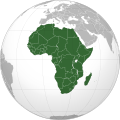
File:Africa (orthographic projection).svg
From Wikipedia, the free encyclopedia

Size of this PNG preview of this SVG file: 550 × 550 pixels. Other resolutions: 240 × 240 pixels | 480 × 480 pixels | 600 × 600 pixels | 768 × 768 pixels | 1,024 × 1,024 pixels.
Original file (SVG file, nominally 550 × 550 pixels, file size: 192 KB)
File history
Click on a date/time to view the file as it appeared at that time.
| Date/Time | Thumbnail | Dimensions | User | Comment | |
|---|---|---|---|---|---|
| current | 00:53, 4 April 2013 |  | 550 × 550 (192 KB) | Spesh531 | reupload |
| 07:48, 12 October 2012 |  | 550 × 550 (182 KB) | Eloquence | broken image, revert to last working version | |
| 15:55, 29 June 2012 | No thumbnail | 550 × 550 (192 KB) | Spesh531 | Changed scheme according to en:Wikipedia:WikiProject Maps/Conventions/Orthographic maps fixed borders | |
| 18:44, 10 July 2011 |  | 550 × 550 (182 KB) | Malus Catulus | readded shadow | |
| 18:28, 10 July 2011 |  | 550 × 550 (180 KB) | Malus Catulus | Sudan border fix | |
| 18:27, 10 July 2011 |  | 550 × 550 (180 KB) | Malus Catulus | Added South Sudan - Sudan border using File:Sudan Sudan (orthographic projection) highlighted.svg, by TUBS, Martin23230, and Spesh531. | |
| 12:16, 26 December 2009 |  | 550 × 550 (132 KB) | Sémhur | + border Eritrea - Etiophia | |
| 05:13, 5 December 2009 |  | 550 × 550 (320 KB) | Keepscases | borders | |
| 11:35, 25 June 2009 |  | 541 × 541 (326 KB) | Martin23230 | {{Information |Description={{en|1=Orthographic map of Africa}} |Source=Own work by uploader |Author=Martin23230 |Date=2009-06-25 |Permission= |other_versions= }} <!--{{ImageUpload|full}}--> Category:Orthographic projections [[Cat |
File usage
More than 100 pages link to this file. The following list shows the first 100 page links to this file only. A full list is available.
- Amasia (continent)
- Americas
- Angola
- Arctica
- Asia
- Atlantica
- Atlantis
- Avalonia
- Baltica
- Benin
- Botswana
- Burkina Faso
- Cameroon
- Central African Republic
- Chad
- Columbia (supercontinent)
- Comoros
- Congo Craton
- Democratic Republic of the Congo
- Demographics of Cuba
- Demographics of France
- Equatorial Guinea
- Ethiopia
- Euramerica
- Europe
- Frankie Fredericks
- French Southern and Antarctic Lands
- Gabon
- Ghana
- Guinea
- Guinea-Bissau
- Hyperborea
- Ivory Coast
- Kalahari Desert
- Kenorland
- Kenya
- Kerguelen Plateau
- Kumari Kandam
- Laurasia
- Lemuria (continent)
- Lesotho
- Liberia
- List of sovereign states and dependent territories by continent
- Madagascar
- Malawi
- Mali
- Maria Mutola
- Mauritius
- Mayotte
- Miruts Yifter
- Mozambique
- Mu (lost continent)
- Namibia
- National routes (South Africa)
- Nena (supercontinent)
- Niger
- Nigeria
- North America
- Northern America
- Oceania
- Old World
- Pangaea Ultima
- Pannotia
- Plazas de soberanía
- Puntland
- Region
- Rodinia
- Rwanda
- Réunion
- Scattered Islands in the Indian Ocean
- Senegal
- Seychelles
- Siberia (continent)
- Sierra Leone
- Somalia
- Somaliland
- South America
- Star Academy
- Subregion
- Sudan
- Sundaland
- Supercontinent
- Swaziland
- Tanzania
- Terra Australis
- The Apprentice (TV series)
- The Gambia
- Togo
- Uganda
- Western Sahara
- World Squash Federation
- Zambia
- Zimbabwe
- Talk:National routes (South Africa)
- User:Anthere
- User:Dubaduba~enwiki/AFR GEO
- Template:Continents of the world
- Template:Countries of Africa
- Category:Categories by continent
- Portal:Africa
Global file usage
The following other wikis use this file:
- Usage on ace.wikipedia.org
- Usage on ady.wikipedia.org
- Usage on af.wikipedia.org
- Usage on am.wikipedia.org
- Usage on an.wikipedia.org
- Usage on ar.wikipedia.org
View more global usage of this file.


