România este un stat situat în Europa. Se învecinează cu Ucraina şi Republica Moldova în nord şi est, Ungaria şi Serbia la vest şi Bulgaria la sud. În sud-est, România are o porţiune de coastă care îi oferă acces la Marea Neagră. Capitala şi cel mai mare oraş este Bucureşti. România este membru al NATO din 2004 şi, din 1 ianuarie 2007, a Uniunii Europene.
Románia európai ország, fővárosa Bukarest. Északkeletről Ukrajna és Moldova határolja, nyugatról Magyarország és Szerbia, délről Bulgária, míg keleten a Fekete-tengerrel határos. Az ország 2007. január 1. óta az Európai Unió tagja.
Romania is a country in Europe. Romania borders ► Hungary and ► Serbia (with ► Vojvodina) to the west, ► Ukraine and ► Moldova to the northeast, and ► Bulgaria to the south. Romania has a stretch of sea coast along the Black Sea, and the eastern and southern Carpathian mountains run through its center.
In other languages
- Deutsch: Rumänien ist eine Republik in Europa, die 850 km von der Pannonischen Tiefebene bis zum Schwarzen Meer reicht. Der Name Romania war im Latein der Spätantike eine verbreitete Kurzbezeichnung für das Römische Reich. Rumänien grenzt an der Republik Moldau, Ukraine, Ungarn, Serbien und Bulgarien. Die Hauptstadt ist Bukarest. Rumänien ist EU- und NATO-Mitglied.
- Romani: Rumuniya si ek them andi Europa. Si somdasno (membro) ando OTNA le 2004to bershestar vi ando Europikano Ekipen katar 1 Yanuara 2007to bersheste.
- Français: la Roumanie est un État situé en Europe, membre de l’Union Européenne et de l'OTAN. Possédant un héritage latin, ce pays est entouré par des pays slaves comme la Bulgarie, la Serbie ou l’Ukraine et par la Hongrie. Il est bordé par la mer Noire au sud-est. Au nord-est, un petit pays également à majorité roumanophone, la République de Moldavie, ne fait plus partie de la Roumanie depuis 1944. La Roumanie, qui est le 7e pays le plus peuplé de l’Union européenne et le 9e par sa superficie, est aussi un pays stratégique pour l'Union européenne, vues ses relations étroites avec les pays de la mer Noire.
- Polski:Rumunia kraj w południowo-wschodniej części Europy. Graniczy z Węgrami i Serbią na zachodzie, Bułgarią na południu wzdłuż Dunaju, oraz Ukrainą i Mołdawią na północy. Kraj ma także dostęp do Morza Czarnego. Bukareszt jest stolicą i największym miastem Rumunii. Od 29 marca 2004 roku Rumunia jest członkiem NATO, a od 1 stycznia 2007 także Unii Europejskiej. Po przyjęciu do organizacji, Rumunia stała się siódmym według liczby ludności krajem wspólnoty.
Short name
Romania
Official name
Romania
Status
United independent country since 1877, recognized 1878 , member of the ► European Union since 2007
Location
Central Europe
Capital
Bucureşti (Bucharest)
Population
22,303,552 inhabitants
Area
238,391 km²
Major languages
Romanian (official), Hungarian (main minority language)
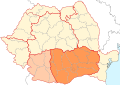
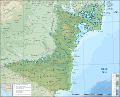
Administrative map of the Romanian Orthodox Church
Administrative map of the Romanian Greek-Catholic (Uniate) Church
Administrative map of the Romanian Roman-Catholic Church
History maps
This section holds a short summary of the history of the area of present-day Romania, illustrated with maps, including historical maps of former countries and empires that included present-day Romania.
The Thraco-Illyrians
Territorial development of the Roman Empire 264 BC-192, including the conquest of Dacia
Kingdom of the Gepids in the 6th century (539-551)
Origins of the Romanians
Vlachs (Romanians) in the territory of present-day Romania in the 6th-8th century (according to the historical atlas for schools, published in Belgrade in 1970, representing a view of Yugoslav historians from that time)
The vlach-bulgarian kingdom under Ivan Assen/Ioan Asan II, 1218-41
The campaigns of Ivan Assen/Ioan Asan II
The wallachian & bulgarian states under the Tsar Todor Svetoslav (1307)
Romanian political entities (states) in the IX - XIII centuries.
Principality of Walachia XIV - XVth century
Principality of Walachia during Mircea the Elder (after 1404)
Amlaş and Făgăraş duchies XIVth-XVth centuries
Growth of the Ottoman Empire
Development of the European part of the Ottoman Empire
Romanian borders according to the Bucharest Peace Treaty (May 1918) and than to WWI Peace Treaties (1919-1920)
Territorial development in the twentieth century
Romania in 1924
Wallachian counties during XIVth - XVIth centuries
Counties, 1480
Counties of Wallachia between 1601 and 1718
Counties of Moldavia between 1601 and 1718
Counties of Wallachia and Moldavia in 1800, according with N. Iorga and C. Giurescu
Counties of Romania between 1856 and 1878
Counties of Romania between 1878 and 1913
Counties of Romania between 1919 and 1925
The original proposal for the administrative unification of interwar Romania (Simion Mehedinţi Commission, 1920)
Counties and regions of Romania before 1926
Romania 1918—1940, Administrative map (after 1926)
The 70 counties of Romania between 1936 and 1939
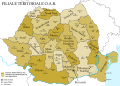
Interwar Romania (administrative map)
Physical map of Romania 1926-1929
Romania in 1930. Administrative map including the counties, the towns and the county subdivisions (plăşi)
Romania in 1938. Administrative map including the counties, the towns and the county subdivisions (plăşi)
Romania 1939, Administrative map
Former Alba county
Former Arad county
Former Argeş county
Former Bacău county
Former Baia county
Former Bălţi county
Former Bihor county
Former Botoşani county
Former Brăila county
Former Braşov county
Former Buzău county
Former Cahul county
Former Caliacra county
Former Caraş county (after 1926)
Former Caraş-Severin county (until 1926)
Former Câmpulung county
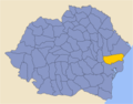
Former Cernăuţi county
Former Cetatea Albă county
Former Ciuc county
Former Cluj county
Former Constanţa county
Former Covurlui county
Former Dâmboviţa county
Former Dolj county
Former Dorohoi county
Former Durostor county
Former Făgăraş county
Former Fălciu county
Former Gorj county
Former Hotin county
Former Hunedoara county
Former Ialomiţa county
Former Iaşi county
Former Ilfov county
Former Ismail county
Former Lăpuşna county
Former Maramureş county
Former Mehedinţi county
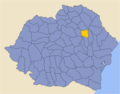
Former Mureş county
Former Muscel county
Former Năsăud county
Former Neamţ county
Former Odorhei county
Former Olt county
Former Orhei county
Former Prahova county
Former Putna county
Former Rădăuţi county
Former Râmnicu Sărat county
Former Roman county
Former Romanaţi county
Former Sălaj county
Former Satu Mare county
Former Severin county (after 1926)
Former Sibiu county
Former Someş county
Former Soroca county
Former Storojineţ county
Former Suceava county
Former Târnava Mare county
Former Târnava Mică county
Former Tecuci county
Former Teleorman county
Former Tighina county
Former Timiş-Torontal county
Former Trei Scaune county
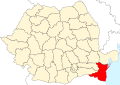
Former Tulcea county
Former Turda county
Former Tutova county
Former Vâlcea county
Former Vaslui county
Former Vlaşca county
Former Tinutul Arges
Former Tinutul Crisuri
Former Tinutul Dunarii
Former Tinutul Jiu
Former Tinutul Marii
Former Tinutul Mures
Former Tinutul Nistru
Former Tinutul Prut
Former Tinutul Suceava
Former Tinutul Timis
Jewish communities in 1930
Romania in September 1940, administrative map
Romania 1940-1941
Romania 1941
Administrative map of the Governorate of Bessarabia (in existence between 1941 and 1944).
Romania controlled (August 19 1941 - January 29 1944) the whole "Transnistrian" region between Dniester, Bug rivers and Black Sea coast. The region was divided into 13 judeţe (counties).
Republic of Banatia (proposed by Banatian Germans at a Paris Peace Conference in 1920)
The dividing of Banat (1919-1923)
Moldavia
The principality of Moldavia in 1483, during the reign of Stephen the Great (1457-1504)
The regions of the historical principality of Moldavia, with the distribution of these regions to modern states
Ethnic map of Hotin County (northern Bessarabia) in 1844
Ethnic map of Hotin County (northern Bessarabia) in 1930
Bukovina
Ethnic map of Bukovina in 1930
The division of Bukovina after the Soviet occupation of the northern half of the province in 1940
Administrative map of the Governorate of Bukovina in May 1942.
Southern Bukovina within the modern Suceava County
Old Maps
Transylvania in 1532, by Johannes Honter
Romania in 1543, by Johannes Honter
Johann Sambucus, Map of Transsylvania
Map of Moldova, 16th century
Moldova by Dimitrie Cantemir, 1716
Walachia and Romania
Balkans, by T. Jefferys, 1785
The oldest known hypotetical map of Rumania (1816)
A hypotetical map of Rumania from 1855
Ethno-linguistic maps
The spread of ethnic Romanians
The 3 main subdivisions of the Daco-Romanians
Romanian varieties
Some representative isoglosses of three main varieties (dialects) of Daco-Romanian
Vlachs in the Balkans
Romanians in Romania (2002)
Romanians in Romania (2011) by counties
Romanians in Transylvania (1850)
Hungarians in Romania, by communes and cities (2002)
Hungarians in Transylvania (1850)
Declared Hungarians in Transylvania (1850)
Declared Szekelys in Transylvania (1850)
Hungarians in Romania, by counties (2002)
Hungarians in Romania, by counties (2011)
Hungarians in Transylvania, Banat, Crişana, Maramureş (2002)
Roma (Gypsies) in Romania (2002)
Roma (Gypsies) in Romania (2002)
Roma (Gypsies) in Romania (2002)
Roma (Gypsies) in Romania (2002)
Roma (Gypsies) in Romania (2011) by counties
Gypsies in Transylvania (1850)
Germans in Romania (2002)
Germans in Transylvania (1850)
Declared Germans in Transylvania (1850)
Declared Saxons in Transylvania (1850)
Ukrainians in Romania (2002)
Russians and Lipovans in Romania (2002)
Turks in Romania (census 2002)
Tatars in Romania (census 2002)
Serbs in Romania (census 2002)
Slovaks in Romania (census 2002)
Bulgarians in Romania (census 2002)
Croats in Romania (census 2002)
Greeks in Romania (census 2002)
Jews in Romania (census 2002)
Jews in Transylvania (1850)
Czechs in Romania (census 2002)
Poles in Romania (census 2002)
Italians in Romania (census 2002)
Armenians in Romania (census 2002)
Armenians in Transylvania (1850)
Eastern Orthodoxy in Romania (census 2002)
Eastern Orthodoxy in Romania (census 1930)
Eastern Orthodoxy in Transylvania (1850)
Roman Catholicism in Romania (census 2002)
Roman Catholicism in Romania (census 1930)
Roman Catholicism in Transylvania (1850)
Protestantism in Romania (census 2002)
Protestantism in Romania (census 1930)
Protestantism in Transylvania (1850)
Reformed (Calvins) in Romania (census 2002)
Reformed (Calvins) in Romania (census 1930)
Reformed (Calvins) in Transylvania (1850)
Pentecostals in Romania (census 2002)
Greek Catholics in Romania (census 2002)
Greek Catholics in Romania (census 1930)
Greek Catholics in Transylvania (1850)
Baptists in Romania (census 2002)
Baptists in Romania (census 1930)
Adventists in Romania (census 2002)
Adventists in Romania (census 1930)
Muslims in Romania (census 2002)
Unitarians in Romania (census 2002)
Unitarians in Romania (census 1930)
Unitarians in Transylvania (1850)
The United Brethrens in Romania (census 2002)
The Old believers in Romania (census 2002)
The distribution of the Lutherans (on the north of the Carpathians) and other Evangelical churches (on the south of the Carpathians) in Romania (census 2002)
Lutherans in Romania (census 1930)
Lutherans in Transylvania (1850)
Ethnic groups in Transylvania (1850)
Ethnic groups in Transylvania (1850) with Saxons and Szeklers
Ethnic map of the European Turkey and its vassal states (1861)
Ethnic map of the Balkan Peninsula (1898)
Vlachs (Romanians) in Hungary, census 1890
Ethnic map of Austria-Hungary, census 1880. German version
Ethnic map of Austria-Hungary, census 1890. English version
Territories inhabited by Romanians in 1908
Territories inhabited by Romanians before the First World War
Religions of Austria-Hungary, including Transsylvania
Linguistic map of Transylvania, Banat, Crisana, Satmar and Maramures in 1910
Historical ethnic map of Transylvania
Transylvanian Saxon settlements (1890)
The Lutheran church in Transylvania (1904)
German-inhabited settlements in Southern Transylvania and the Romanian Banat in 1940
Ethnic map of Romania according to the 1930 census
Ethnic map of Bessarabia according to the 1930 census
Ethnic map of Romania (including Transnistria) in 1941
Ethnic composition of the (Romanian) Governorate of Bessarabia in 1941
Ethnic map of Romania (census 1977)
Ethnic map of Romania (census 1992)
Ethnic map of Romania (census 2002)
Ethnic map of Romania (census 2011) by communes and cities
Ethnic map of Romania (census 2011) by counties
Religious map of Romania (census 2002)
Religious map of Romania (census 1930)
Religions in Transylvania (1850)
Foreign residents in Romania (census 2002) by country of citizenship
Visa requirements for Romanian citizens
Satellite maps
Satellite image of Romania in December 2001
Regional topographic maps
Topographic map of Dobruja
Topographic map of the area surrounding the city of Sibiu/Hermannstadt, Southern Transylvania (scale 1:100.000)
Topographic map of the area surrounding the town of Targu Neamt, Moldavia (scale 1:75.000)
Economy maps
Agriculture production (1898)
Oilfields in Romania (1900)
Romania - Basic Resources and Processing (1970)
Industrial centers (1970)
Romanian economy (1990)
Romania - Land Utilization (1970)
Romania - Land Use (1990)
Income in Romania
Contributions to the Romanian budget
The waterway that connects the North Sea with the Black Sea
Illiteracy in Romania 2011
Literacy in Romania 1930
Crime map (2009)
Homicides in Romania
Suicides in Romania
Car accidents in Romania
Romanian Order of Architects
Election maps
Results of the 1937 general elections at county level
Results of the 2008 local elections at county and municipality level
Results of the 2008 legislative elections in the Senate constituencies within Romania
Results of the 2008 legislative elections in the Chamber of Deputies constituencies within Romania
Notes and references
General remarks:
The WIKIMEDIA COMMONS Atlas of the World is an organized and commented collection of geographical, political and historical maps available at Wikimedia Commons. The main page is therefore the portal to maps and cartography on Wikimedia. That page contains links to entries by country, continent and by topic as well as general notes and references.
Every entry has an introduction section in English. If other languages are native and/or official in an entity, introductions in other languages are added in separate sections. The text of the introduction(s) is based on the content of the Wikipedia encyclopedia. For sources of the introduction see therefore the Wikipedia entries linked to. The same goes for the texts in the history sections.
Historical maps are included in the continent, country and dependency entries.
The status of various entities is disputed. See the content for the entities concerned.
The maps of former countries that are more or less continued by a present-day country or had a territory included in only one or two countries are included in the atlas of the present-day country. For example the Ottoman Empire can be found in the Atlas of Turkey.


_Church_map.svg)


.svg)


.jpg)


.JPG)


.jpg)


.svg)


.JPG)


-ro.png)


.PNG)


.png)

.png)
.png)
_in_Transilvania_(1850).png)
.png)
.png)


_Romania_2002.png)


.png)
.png)
_in_Transilvania_(1850).png)
.png)
.png)


.png)

.png)

.png)
.png)
.PNG)
.png)
.png)
.png)
.png)
.png)
.png)
.png)
.png)
.png)

.png)
.png)

.png)
.png)

.png)
.png)
_Transilvania_1850.png)
.png)
.png)
.png)

.png)
.png)
.png)
.png)
.png)
.png)
.png)

.png)
_Romania_(2002).png)
_in_Romania_(2002).png)
.png)
_Transilvania_1850.png)

.png)
.jpg)

_in_Hungary,_census_1890.jpg)
.jpg)
.JPG)


.jpg)

.JPG)

.JPG)


.png)


.JPG)
.jpg)
.jpg)
.jpg)
.jpg)
.jpg)

.map.PNG)


.PNG)


