Atlas of India

From Wikimedia Commons, the free media repository
Jump to: navigation, search
Internet-web-browser.svg Wikimedia Commons Atlas of the World

The Wikimedia Atlas of the World is an organized and commented collection of geographical, political and historical maps available at Wikimedia Commons.
Discussion • Update the atlas • Index of the Atlas • Atlas in categories • Other atlases on line
Commons-logo.svg
The introductions of the country, dependency and region entries are in the native languages and in English. The other introductions are in English.
 
India in its region (claimed and disputed hatched).svg
India

Flag of India.svg

भारत
India
ভাৰত
ভারত
ભારત
ಭಾರತ
ഇന്ത്യ
ଭାରତ
ਭਾਰਤ
இந்தியா
భారత దేశము
بھارت

हिन्दी[1] भारत - भारत गणराज्य (Bhārat - Bhārata Gaṇarājya)


भारत गणराज्य दक्षिण जंबुद्वीप में स्थित एक देश है। यह भारतीय उपमहाद्वीप का सबसे बड़ा देश है। भारत की समुद्र तट रेखा 7000 किलोमीटर लम्बी है। भारत, भौगोलिक दृष्टि से विश्व का सातवां सबसे बड़ा और जनसंख्या के दृष्टिकोण से दूसरा सबसे बड़ा देश है। भारत के पश्चिम में पाकिस्तान, उत्तर-पूर्व मे चीन, नेपाल, और भूटान और पूर्व में बांग्लादेश और म्यांमार देश स्थित हैं। हिन्द महासागर में इसके दक्षिण पश्चिम में मालदीव, दक्षिण में श्रीलंका और दक्षिण-पूर्व में इंडोनेशिया है। भारत उत्तर-पश्चिम में अफ़ग़ानिस्तान के साथ सीमा का दावा करता है।

English India - Republic of India

The Republic of India is a country in South Asia. It is the seventh-largest country by geographical area, the second most populous country, and the largest democracy in the world. India has a coastline of over seven thousand kilometres, bounded by the Indian Ocean on the south, the Arabian Sea on the west, and the Bay of Bengal on the east. India borders ► Pakistan to the north-west; ► China (with ► Tibet), ► Nepal to the north; and ► Bangladesh, ► Bhutan to the north-east; and ► Myanmar to the east. In the Indian Ocean, India is in the vicinity of ► Sri Lanka, ► Maldives and ► Indonesia are to the south. In the north west, India claims sovereignty over parts of ► Kashmir.

বাংলা[2]) ভারত - ভারত গণরাজ্যভারত গণরাজ্য দক্ষিণ এশিয়ার একটি রাষ্ট্র। এর রাজধানী নয়া দিল্লী। এই দেশটির সীমানা হল পশ্চিমদিকে পাকিস্তান, উত্তর দিকে চীন, নেপাল ও ভুটান, পূর্ব দিকে বাংলাদেশ ও মায়ানমার। এছাড়া ভারতে ৭০০০ কিলোমিটারেরও বেশী দীর্ঘ সমুদ্র সৈকত রয়েছে। বঙ্গোপসাগর, আরব সাগর ও ভারত মহাসাগর দেশটিকে দক্ষিণদিকে ঘিরে রেখেছে।
ଓଡିଆ[3]) ଭାରତ - ଭାରତ ଗଣରାଜ୍ଯ ଦକ୍ଷିଣ ଏସିଆରେ ଅବସ୍ଥିତ ଏକ ଦେଶ ଅଟେ । ଭୌଗଳିକ ଦୃଷ୍ଟିରୁ ଏହା ପୃଥିବୀର ସପ୍ତମ ବୃହତ୍ତମ, ଜନସଂଖ୍ଯା ଦୃଷ୍ଟିକୋଣରୁ ଦ୍ବିତୀୟ ସର୍ବବୃହତ୍‌ ଦେଶ ଅଟେ । ଏହ ପୃଥିବୀର ସର୍ବବୃହତ୍ତ ଗଣତନ୍ତ୍ର ମଧ୍ଯ ଅଟେ । ଭାରତୀୟ ସାମୁଦ୍ରିକ ତଟରେଖା ସାତହଜାର କିଲୋମିଟର ଦୀର୍ଘ ଅଟେ । ଦକ୍ଷିଣରେ ଭାରତୀୟ ମହାସାଗର, ପଶ୍ଚିମରେ ଆରବ ମହାସାଗର ଏବଂ ପୂର୍ବରେ ବଙ୍ଗୋପ ମହାସାଗର ଦ୍ବାରା ଏହା ପରିବେଷ୍ଟିତ । ଭାରତର ଉତ୍ତର-ପଶ୍ଚିମରେ ► ପାକିସ୍ତାନ; ଉତ୍ତରରେ ► ଚୀନ୍‍ (► ତିବ୍ବତ ସହିତ), ► ନେପାଳ; ଏବଂ ଉତ୍ତର-ପୂର୍ବରେ ► ବାଂଲାଦେଶ► ଭୂଟାନ ତଥା ପୂର୍ବରେ ► ମ୍ଯାମାର୍‌ ଅବସ୍ଥିତ । ଦକ୍ଷିଣରେ ଭାରତ ମହାସାଗରେ ଅବସ୍ଥିତ ► ଶ୍ରୀଲଙ୍କା► ମାଳଦ୍ବୀପ ମଧ୍ଯ ଭାରତର ପଡୋଶୀ ରାଷ୍ଟ୍ର ଅଟନ୍ତି ।
తెలుగు[4]) భారత దేశము - భారత గణ రాజ్యము (Bhāratavarsha)

భారత గణతంత్ర రాజ్యము వంద కోట్లకు పైగా జనాభా తో ప్రపంచం లో అత్యధిక జనాభా కలిగిన దేశాలలో రెండవది. వైశాల్యము లో ప్రపంచం లో ఏడవది. భారత దేశ ప్రాముఖ్యత గత రెండు దశాబ్దాలలో గణనీయంగా పెరిగింది. భారత ఆర్ధిక వ్యవస్థ యొక్క స్థూల జాతీయోత్పత్తి పర్చేసింగ్ పవర్ పారిటీ ప్రకారం నాలుగో స్థానంలో ఉంది. ప్రపంచంలో అతివేగంగా వృద్ధి చెందుతున్న వ్యవస్థలలో ఇది ఒకటి. ప్రపంచం లోనే అతి పెద్ద స్వేచ్ఛాయుత ప్రజాస్వామ్యము ఐన భారతదేశం, ప్రపంచం లోనే అతి పెద్ద సైనిక సామర్థ్యం కలిగి ఉన్న దేశాలలో ఒకటిగా, అణ్వస్త్ర సామర్థ్యం కలిగన దేశంగా ఒక ముఖ్యమైన ప్రాంతీయ శక్తిగా ఆవిర్భవించినది.

मराठी[5] भारत - भारत गणराज्य (Bhāratavarsha)

भारत गणराज्य(प्रजासत्ताक) हा दक्षिण जंबुद्वीप मध्ये स्थित देश आहे. हा भारतीय उपखंडातील सगळ्यात मोठा देश आहे. भारतीय सामुद्रीक सीमा ७००० किलोमीटर विस्तीर्ण आहे. भारत, भौगोलिक दृष्टया जगात सातवा सगळ्यात मोठा तर लोकसंख्या दृष्टया दुसरा मोठा देश आहे. भारताच्या पश्चिमेस पाकिस्तान, ईशान्येस चीन, नेपाल, आणि भूतान, पूर्वेस बांग्लादेश आणि म्यांमार देश आहेत. नैॠत्येस मालदीव बेट, दक्षिणेस श्रीलंका आणि आग्नेयेस इंडोनेशिया आहे. भारताची वायव्य सीमा अफगाणिस्तान देशास जोडलेली आहे.

தமிழ்[6] இந்தியா (Indhiya) - இந்தியக் குடியரசு (Indhiya Kudiyarasu)

இந்தியா, தெற்கு ஆசியாவில் உள்ள ஒரு குடியரசு நாடாகும். இந்தியா, இந்திய துணைக்கண்டத்தின் பெரும் பகுதியை தன்னுள் அடக்கியுள்ளது. இந்தியா பாரதம் என்றும் அழைக்கப் படுகிறது. இந்தியா என்ற பெயர் சிந்து நதியின் பெயரிலிருந்து பெறப்பட்டது. பரப்பளவில் இந்தியா ஏழாவது இடத்தில் உள்ள நாடு. இந்தியாவின் கடற்கரை மொத்தம் 7000 கி.மீ. நீளம் கொண்டது. நிலப்பகுதியில், வங்காளதேசம், மியன்மார், சீனா, பூட்டான், நேபாளம் மற்றும் பாகிஸ்தான் என்பவற்றுடன் இந்தியா எல்லைகளைக் கொண்டுள்ளது. இலங்கையும், மாலத்தீவும் இந்தியக்கரைக்கு அப்பால் இந்தியப் பெருங்கடலில் உள்ளன.

മലയാളം[7]  : ഇന്ത്യ- ഇന്ത്യ ദക്ഷിണേഷ്യയിലെ ഒരു രാജ്യമാണ്. ലോകത്തില്‍ വലിപ്പം കൊണ്ട് ഏഴാമതും ജനസംഖ്യയില്‍ രണ്ടാമതും ആണ് ഇന്ത്യ. പടിഞ്ഞാറ് അറബിക്കടലും കിഴക്ക് ബംഗാള്‍ ഉള്‍ക്കടലും ചേര്‍ന്ന് ഏഴായിരം കിലോമീറ്റര്‍ തീരദേശം ഇന്ത്യയ്ക്ക് ഉണ്ട്.
Names in other languages Other languages

Short name  India
Official  name Republic of India
Status Independent country since 1947
Location South Asia
Capital नई दिल्ली (New Delhi)
Population 1,103,371,000 inhabitants
Area 13,166,414 km²
Major  languages Hindi, English (both official), 21 regional official languages[8]
Major  religions Hinduism, Islam, Christianity, Buddhism, Sikhism, Jainism and others
More information India, Geography of India, History of India and Politics of India
More  images India - India (Category).

General maps

Map India.png Map of India
Modern india.png Map of India
Indian subcontinent CIA.png Map of India
South Asia UN.png India and surrounding countries
India map en.svg Labeled map of India showing international borders, state borders, district borders, rivers and lakes
States of South Asia 1.png South Asia in local languages
India physical map.svg Physical map
India-physical-map.png Physical map

Maps of divisions

This section holds maps of the administrative divisions.

India states and union territories map.svg States and territories of India
India ter.jpg States and territories of India
State and union territories map.png States and territories of India
India ter1.jpg Map of India with territories marked
India districts.png Districts of India
India disputed areas map.svg India disputed areas

Maps of Kashmir

Kashmir map big.jpg Kashmir
Kashmir map.jpg Divided Kashmir
Kashmir map NL.png Kashmir

History maps

This section holds a short summary of the history of the area of present-day India, illustrated with maps, including historical maps of former countries and empires that included present-day India.

IVC Map.png Indus Valley Civilization (2600-1900 BCE)
Map of Vedic India.png Vedic civilization (1500-500 BCE)
Vedic India.jpg Vedic civilization
EpicIndia.jpg "Bharatvarsha" (Kingdom of India) during the time of Mahabharata and Ramayana
Ancient india.png Ancient India 600 BC
Gandhara.JPG Gandhara
Magadha.GIF Magadha (500 BCE)
Nandas.JPG Nanda Dynasty (400 BCE)
Maurya india.png Maurya and Gupta Empires
[[|border|251x400px]] Mauryan Empire (250 BCE)
Mauryans.JPG Mauryan Empire
Mauryan Empire Map.gif Mauryan Empire
Chandragupta mauryan empire.GIF Mauryan Empire
Guptaempire.gif Gupta Empire
SatavahanaMap.jpg Category:Satavahana empire
Indo-GreekKingdomMap11.jpg Indo-Greek kingdom (180 BCE-10 AD)
Indo-GreekKingdomMap3.jpg Indo-Greek Kingdom
AtlasIndoGreek.jpg Indo-Greek Kingdom
Indo-GreekMapColor.jpg Indo-Greek Kingdom
Kalinga.GIF Kalinga
KushanEmpireMap.jpg Kushan Empire
WKshatrapas.jpg Western Kshatrapas(35-405 AD)
[[|border|251x400px]] Chera Dynasty
Pandya territories.png Pandyas (100-1250)
Gupta.png Gupta Empire (400 AD)
Guptariket karta.jpg Gupta Empire
Guptaempire.gif Gupta Empire
Indo-Sassanid.jpg Gupta Empire
Kalabhras territories.png Kalabhras (400)
Indian Kadamba Empire map.svg Kadamba Empire (450)
Hephthalite.png Hephthalite dominion (520)
Harshabysumchung.jpg Harsha's Empire around 600
Pallava territories.png Pallava (645)
Pratihara.JPG Pratihara (6th-11th century)
Rajput mahrajas.JPG Rajput Kingdoms (7th-11th Century)
Pala.JPG Pala Empire (700-1200)
Indian Kanauj triangle map.svg Kanauj Empire (750-900)
Indian Rashtrakuta Empire map.svg Rashtrakuta Empire (750-900)
LocationChola empire sm.png Chola Empire (1050)
Kulothunga territories cl.png Chola Empire
Chola map.png Chola Empire
Rajendra territories cl.png Chola Empire
Chalukya territories new2.png Chalukya (735-1120)
Rashtrakuta territories.png Rashtrakuta (780)
Rashtrakuta-empire-map.svg Rastrakuta (735-982)
Western-chalukya-empire-map.svg Western Chalukyas (973-1200)
Hoysala Empire extent.svg Hoysala Empire (1000-1346)
Vijayanagara-empire-map.svg Vijayanagara Empire (1336-1646)
Delhi sultanate.JPG Delhi Sultanate (13th century)
Sultanat von Delhi Tughluq-Dynastie.png Delhi Sultanate during the Tughlaq dynasty 1320-1330
Delhisultanatet under iltutmish.jpg Delhi Sultanate under Iltutmish
Karta sodra indien 1500.jpg South India in 1500
Mysore.JPG Kingdom of Mysore (1400-1947)
Sher Shah's empire.png Sher Shah's Empire (around 1500)
European settlements in India 1501-1739.png European settlements in India 1501-1739
Stormogulernas rike 1600.jpg Mughal Empire (1600) and European possesions
Mogulreich Akbar.png Mughal Empire in 1605
Mughal empire large.png Mughal Empire (1526-1857)
Mughal1700.png Mughal Empire
Moghol.jpg Mughal Empire
Maratha Empire 1680.PNG Maratha Empire, 1680
Mogulriket 1690.jpg Mughal Empire 1690
India shepherd 1923.jpg India 1700-1792
French India 1741-1754.png French India 1741-1754
India-1760-map.jpg Maratha Empire in 1760
Joppen1907India1795a.jpg Maratha Confederacy in 1794
Joppen1907India1805a-21.jpg Maratha Confederacy (yellow), Sikh Empire (green) and British India (red), 1805
British india.png British India 1860
British india.JPG British India, not including Burma
Indian revolt of 1857 states map.svg Revolt of 1857
Anglo-Mysore War 1 and 2.png Anglo-Mysore Wars
Anglo-Mysore War 3.png Anglo-Mysore Wars
Anglo-Mysore War 4.png Anglo-Mysore Wars
Partition of India.PNG Britain's holdings on the Indian subcontinent were granted independence in 1947 and 1948, becoming four new independent states: India, Burma (now Myanmar), Ceylon (now Sri Lanka), and Pakistan (including East Pakistan, modern-day Bangladesh)
Partage de l'Inde.svg Partition of India

Old maps

This section holds copies of original general maps more than 70 years old.

Hindoostanmap1812.jpg Hindustan in 1812 by Arrowsmith and Lewis
Bengal map 1893.JPG Map of Bengal 1893
Bengal gazetteer 1907-9.jpg Map of Eastern Bengal and Assam 1907

Ethno-linguistic maps

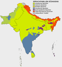
Südasien Sprachfamilien.png Languages of South Asia
Indoarische Sprachen.png Indo-arian languages
Dravidische Sprachen.png Dravidian languages
Cultural regional areas of India.png Cultural regional areas
Hindi belt.GIF Hindi Belt
Alphabetisierungsrate.png Literacy rate
India literacy rate map en.svg Literacy rate

Other maps

India-geology-map.png Geology map
Indiahills.png Hills of India
Indiarivers.png Rivers of India
Rivers and lakes map.png Rivers and lakes of India
India annual rainfall map en.svg Annual rainfall
Ausbreitung Indischer Sommermonsun.png Indian Summer
India wind zone map en.svg Wind Zone map
India-naturalhazards-map.png Natural hazards
Indiatemperaturetemp.png Temperature map
India population density map en.svg Population density
India decadal growth rate map en.svg Decadal growth rate
Airports and seaports map.png Air- and seaports
India-geology-map.png Geological map
India climatic zone map en.svg Climatic zones
India annual rainfall map.svg Annual rainfall
India average annual temperature map en.svg Average annual temperature
India climatic disaster risk map en.svg Climatic disaster risk
India earthquake zone map en.svg Earthquake zones
India flood zone map.svg Flood zones
India sex ratio map en.svg Sex ratio
Indian Jews communities map.png Jewish communities
Indian Railways network.png Railways

satellite-maps

India 78.40398E 20.74980N.jpg Satellite map

Notes and references

General remarks:

  • The WIKIMEDIA COMMONS Atlas of the World is an organized and commented collection of geographical, political and historical maps available at Wikimedia Commons. The main page is therefore the portal to maps and cartography on Wikimedia. That page contains links to entries by country, continent and by topic as well as general notes and references.
  • Every entry has an introduction section in English. If other languages are native and/or official in an entity, introductions in other languages are added in separate sections. The text of the introduction(s) is based on the content of the Wikipedia encyclopedia. For sources of the introduction see therefore the Wikipedia entries linked to. The same goes for the texts in the history sections.
  • Historical maps are included in the continent, country and dependency entries.
  • The status of various entities is disputed. See the content for the entities concerned.
  • The maps of former countries that are more or less continued by a present-day country or had a territory included in only one or two countries are included in the atlas of the present-day country. For example the Ottoman Empire can be found in the Atlas of Turkey.
  1. Hindi
  2. Bengali
  3. Oriya
  4. Telugu
  5. Marathi
  6. Tamil
  7. Malayalam
  8. See Official languages of India.

Entries available in the atlas

General pages
Atlas • Historical atlas • Index of the Atlas • Names in native languages

The world and its continents and oceans
Quick reference • Historical maps of the world • Old maps
Physical and topographical • Political • Geological • People • Time and time zones • Projections of the globe
Africa • North and South America • Antarctica • Asia • Europe

(History, European Union) • Oceania • Oceans

Themes
Administrative divisions • International organizations • Languages • Religions

Historical eras
Prehistory • Antiquity • Middle Ages • Rise of Islam • Early Modern Age • Early American Societies • Early Asian Societies • Age of Renaissance • Colonialism • Stielers Handatlas 1891 • 20th Century • World War I • World War II

Entities with undisputed sovereign status
Afghanistan • Albania • Algeria • Andorra • Angola • Antigua and Barbuda • Argentina • Armenia • Australia • Austria • Azerbaijan • Bahamas • Bahrain • Bangladesh • Barbados • Belarus • Belgium • Belize • Benin • Bhutan • Bolivia • Bosnia and Herzegovina • Botswana • Brazil • Brunei • Bulgaria • Burkina Faso • Burundi • Cambodia • Cameroon • Canada • Cape Verde • Central African Republic • Chad • Chile • China • Colombia • Comoros • Congo (Democratic Republic) • Congo (Republic) • Costa Rica • Côte d’Ivoire • Croatia • Cuba • Cyprus • Czech Republic • Denmark • Djibouti • Dominica • Dominican Republic • East Timor • Ecuador • Egypt • El Salvador • Equatorial Guinea • Eritrea • Estonia • Ethiopia • Fiji • Finland • France • Gabon • Gambia • Georgia • Germany • Ghana • Greece • Grenada • Guatemala • Guinea • Guinea-Bissau • Guyana • Haiti • Honduras • Hungary • Iceland • India • Indonesia • Iran • Iraq • Ireland • Israel • Italy • Jamaica • Japan • Jordan • Kazakhstan • Kenya • Kiribati • Korea (Democratic People’s Republic) • Korea (Republic) • Kuwait • Kyrgyzstan • Laos • Latvia • Lebanon • Lesotho • Liberia • Libya • Liechtenstein • Lithuania • Luxembourg • Macedonia (Republic) • Madagascar • Malawi • Malaysia • Maldives • Mali • Malta • Marshall Islands • Mauritania • Mauritius • Mexico • Micronesia (Federated States) • Moldova • Monaco • Mongolia • Montenegro • Morocco • Mozambique • Myanmar • Namibia • Nauru • Nepal • The Netherlands • New Zealand • Nicaragua • Niger • Nigeria • Norway • Oman • Pakistan • Palau • Panama • Papua New Guinea • Paraguay • Peru • Philippines • Poland • Portugal • Qatar • Romania • Russia • Rwanda • Saint Kitts and Nevis • Saint Lucia • Saint Vincent and the Grenadines • Samoa • San Marino • São Tomé and Príncipe • Saudi Arabia • Senegal • Serbia • Seychelles • Sierra Leone • Singapore • Slovakia • Slovenia • Solomon Islands • Somalia • South Africa • South Sudan • Sovereign Military Order of Malta • Spain • Sri Lanka • Sudan • Suriname • Swaziland • Sweden • Switzerland • Syria • Tajikistan • Tanzania • Thailand • Togo • Tonga • Trinidad and Tobago • Tunisia • Turkey • Turkmenistan • Tuvalu • Uganda • Ukraine • United Arab Emirates • United Kingdom • United States • Uruguay • Uzbekistan • Vanuatu • Vatican City • Venezuela • Vietnam • Yemen • Zambia • Zimbabwe

Entities with disputed sovereign status
Abkhazia • Azawad • China (Republic)/Taiwan • Islamic State • Kosovo • Nagorno-Karabakh Republic • New Russia • Northern Cyprus • Palestine • Somaliland • South Ossetia • Tamil Eelam • Transnistria • Western Sahara

Dependencies and other overseas territories
Akrotiri and Dhekelia • Åland • American Samoa • Anguilla • Aruba • Ascension Island • Ashmore and Cartier Islands • Baker Island • Bermuda • Bouvet Island • British Indian Ocean Territory • British Virgin Islands • Cayman Islands • Christmas Island • Clipperton Island • Cocos (Keeling) Islands • Cook Islands • Coral Sea Islands • Curaçao • Faroe Islands • French Guiana • French Polynesia • French Southern and Antarctic Lands • Gibraltar • Greenland • Guadeloupe • Guam • Guantanamo Bay • Guernsey • Heard Island and McDonald Islands • Hong Kong • Howland Island • Isle of Man • Jan Mayen • Jarvis Island • Jersey • Johnston Atoll • Kingman Reef • Macau • Martinique • Mayotte • Midway Atoll • Montserrat • Navassa Island • New Caledonia • Niue • Norfolk Island • Northern Mariana Islands • Palmyra Atoll • Pitcairn Islands • Puerto Rico • Réunion • Saint Helena • Saint-Barthélemy • Saint Martin (France) • Sint Maarten (Netherlands) • Saint-Pierre and Miquelon • Svalbard • Tokelau • Tristan da Cunha • Turks and Caicos Islands • United States Virgin Islands • Wake Island • Wallis and Futuna

Disputed subnational entities and territories
Crimea • Cyrenaica • Galmudug • Himan and Heeb • Jubaland • Kashmir • Khatumo • Kurdistan (Syrian) • Paracel Islands • Puntland • Spratly Islands • Falkland Islands • South Georgia and South Sandwich Islands • Bajo Nuevo Bank • Serranilla Bank • Southwestern Somalia

Subnational autonomous entities
Aceh • Adjara • Adygea • Altai • Andalusia • Aosta Valley • Aragon • Asturias • Athos • Azores • Balearic Islands • Bashkortostan • Basque Autonomous Community • Bonaire • Bosnia and Herzegovina (Federation of) • Bougainville • Brussels • Buryatia • Canary Islands • Catalonia • Chechnya • Chuvashia • Corsica • Dagestan • Easter Island • England • Extremadura • Flanders • Friuli-Venezia Giulia • Gagauzia • Galicia • Galápagos Islands • Gorno-Badakhshan • Guangxi • Ingushetia • Inner Mongolia • Kabardino-Balkaria • Kalmykia • Karachay-Cherkessia • Karakalpakstan • Karelia • Khakassia • Komi • Kurdistan (Iraqi) • Madeira • Mari El • Muslim Mindanao • Mordovia • Nakhichevan • Navarre • Nevis • Ningxia • North Ossetia-Alania • Northern Ireland • Nunatsiavut • Quebec • Saba • Sakha • Sardinia • Scotland • Sicily • Sint Eustatius • Srpska • Tatarstan • Tibet • Tłı̨chǫ • Trentino-Alto Adige • Tuva • Udmurtia • Vojvodina • Wales • Wallonia • Xinjiang • Zanzibar

Other regions
Basque Country • Burzenland • Catalan Countries • Frisia • Kurdistan • Sandžak • Sápmi • Svenskfinland • Székely Land • Transylvania

Former sovereign nations
Austria-Hungary • Byzantine Empire • Caliphate • Czechoslovakia • Republic of West Florida • Frankish Empire • Kingdom of Hawaiʻi • Inca Empire • Iroquois Confederacy • Macedonian Empire • Ottoman Empire • Prussia • Roman Empire • Soviet Union • Republic of Texas • Vermont Republic • Yugoslavia

Former dependencies and overseas territories
Netherlands Antilles