a. Synoptic History
Satellite imagery showed an increase in cloudiness and thunderstorms over a broad
area located several hundred miles off the southwest coast of Mexico on 22 June.
This disturbance may have originated from a tropical wave
that moved from Africa to the eastern Atlantic Ocean on June 8. However, the wave was very poorly
defined on satellite imagery for several days while it passed over the Caribbean and
Central America, and only continuity can be used to track the wave into the
eastern Pacific.
Intermittent Dvorak classifications were made on
the disturbance on 23 and 24
June. Deep convection became more concentrated and the "best track"
indicates that a tropical depression formed from the disturbance
near 0600 UTC 25 June, while centered about 450 n mi south-southeast of the southern tip of Baja California
(Fig. 1 (25K GIF)and Table 1). The
developing cyclone moved toward the northwest near 10 knots.
The tropical depression strengthened into
Tropical Storm Carlos by 1800 UTC 25
June as upper-level outflow became better established and convective banding increased.
A minimum central pressure of 996 mb and maximum winds of 45 knots
are estimated to have occurred near 0600 UTC 26 June. At this time, the cyclone
was centered about 40 n mi south-southwest of Socorro Island.
Convective activity soon diminished as Carlos moved over cooler water.
Upper-level shear increased and by 27 June the low-level center was
exposed from the convection. The movement of the tropical cyclone
had become more westerly by this time in response to the low-level steering. Carlos weakened to a
tropical depression near 0600 UTC 27 June when only minimal deep convection remained.
The best track indicates dissipation by 0600 UTC 28 June about 500 n mi west-southwest of the southern
tip of Baja California, although a weak swirl in the low clouds persisted for another day or so.
b. Meteorological Statistics
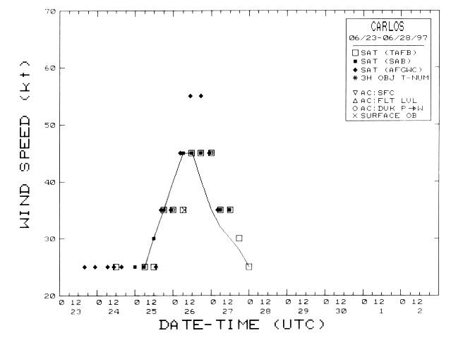
Figures 2 (21K GIF) and
3 (20K GIF) show best track curves of minimum
central pressure and maximum one-minute surface wind speed, respectively, as a function of time.
The observations on which the curves are based are also plotted and consist primarily of
Dvorak-technique estimates using satellite imagery. The lowest surface pressure
reported from Socorro Island was 1001.1 mb at 0700 UTC 26 July, at which time maximum
sustained winds were measured at 35 knots with gusts to 53 knots.
c. Casualty and Damage Statistics
No reports of casualties or damage associated with Carlos have been received at the
NHC.
d. Forecast and Warning Critique
Official forecasts correctly indicated the general west-northwestward track as well
as the intensification into a minimal tropical storm followed by weakening back
into a tropical depression. However, no meaningful verifications can be made since
Carlos was categorized as a tropical storm for only a little longer than a day.
With the exception of Socorro Island, the tropical storm did not threaten land. The
Government of Mexico did not post watches or warnings.
![[NCEP Logo]](/web/20050925163528im_/http://www.nhc.noaa.gov/graphics/ncep.gif)