The Water Channel
 Video and Multimedia

Funding Protects an Environmental Treasure
Funding for advanced wastewater treatment helps protect Apalachicola Bay, one of the nation's great estuaries.
Discover Florida's Freshwater Springs

Florida is blessed with one of the largest concentrations of freshwater springs in the world. These amazing ecosystems provide habitat for manatees and many other unique species as well as recreational opportunities for residents and visitors. They also provide a unique glimpse into the health of our aquifer.
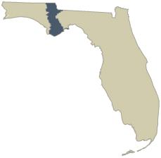
Learn About Your Watershed
Apalachicola River-Chipola River Watershed

Watershed Stats
Size of Basin: 3,067 square miles
Major Cities and Towns: Camp Bellton, Malone, Bascom, Jacob City, Greenwood, Cottondale, Alford, Marianna, Grand Ridge, Sneads, Chattahoochee, Altha, Blountstown, Bristol, Wewahitchka, Apalachicola, Eastpoint, Carrabelle, and Port St. Joe
Counties: The majority of the watershed lies within Jackson, Calhoun, Franklin, and Liberty Counties, and smaller areas lie within Gulf, Bay, Washington, and Gasdsen Counties
Major Water Features: Apalachicola Bay, East Bay, St. George Sound, Money Bayou, Dead Indian Lagoon, and Alligator Harbor
Rivers: Apalachicola, Chattahoochee, Flint River (within Georgia), Chipola, Styx, Crooked, Brothers, Jackson, Saint Marks, and East Rivers
Creeks: Huckleberry, Mosquito, Flat, Sutton, Cowarts, Waddells Mill, Whiskey George, Jenkins, Ocheesee, Graves, Stafford, Little Gully, Depot, Gully, Kennedy, Black, Cypress, Fort Gadsden, Irwin Mill, Marshall, Dry, Rocky, Juniper, Sweetwater, Stone Mill, Tenmile, Black, Gator, and Pine Log Creeks; Mary Branch, Dry Branch, Muddy Branch, Cat Branch, and Hays Spring Run
Springs: Glen Julia, Sinai, Mill Pond, Bosel, and Blue Hole Springs
Lakes: Lake Seminole, Lake Wimico, Merritts Mill Pond, Lake Mystic, and Outside Lake
Overview

The Apalachicola River headwaters actually begin in Georgia with the Chattahoochee River, north of Atlanta. The river is renamed the Apalachicola where it crosses the Georgia-Florida border and is joined by the Flint River. The majority of the watershed lies within Georgia, a small portion is in Alabama, and only about 20 percent lies within Florida. Not only is this basin biologically unique because of its origin in the Appalachian Mountains, it also contains one of the most diverse, productive, and economically important natural systems in the southeastern United States. The Apalachicola watershed is home to a great diversity of wildlife species and many endemic plant species. The watershed has the greatest number of freshwater fish species in Florida, with 86 species identified. It also provides habitat for 315 bird species and 52 mammalian species, many of which are threatened or endangered.
The water flows of the Chattahoochee and Flint Rivers define the Apalachicola River's physical and biological characteristics. The Apalachicola River is one of four alluvial rivers in the Florida Panhandle. Its discharge accounts for 35 percent of the total freshwater runoff from Florida's west coast. Some areas along the river have bluffs over 150 feet tall, while its floodplain, the largest in Florida, is composed of bottomland hardwood and cypress/tupelo swamps.
For many years, the bay has supported the largest oyster-harvesting industry in Florida, as well as extensive shrimping, crabbing, and commercial fishing.
The Chipola River, the main tributary to the Apalachicola River, originates in southern Alabama and goes underground for a short distance at Marianna, Florida. The river flows out of the limestone highlands and empties into a low, swampy area fed mostly by blackwater tributaries. The Chipola watershed provides habitat for a number of threatened and endangered animal and plant species. Jackson Blue Spring is the watershed's only first-magnitude spring, with an average discharge of 122 million gallons per day.
The Apalachicola River originates in the Appalachian Mountains, and its watershed contains the most diverse, productive, and economically important natural systems in the southeastern United States.
The New River watershed drains about 503 square miles of low, wet forest in coastal Liberty and Franklin Counties. The river's headwaters lie in the Apalachicola National Forest, and the river flows through Tates Hell Swamp, a vast, forested plain that was extensively ditched, drained, and cleared for silviculture in the mid-1960s and late 1990s. The river is very darkly stained, making it one of the "blackest" of the blackwater streams. After its confluence with Crooked River, the stream becomes wider and estuarine in character and is called the Carrabelle River.

The Apalachicola River plays an integral role in the ecology of Apalachicola Bay. This estuary serves as the interface between the freshwater uplands and the Gulf of Mexico. The bay is bounded by four barrier islands: St. Vincent Island, St. George Island, Cape St. George Island, and Dog Island. Apalachicola Bay is an exceptionally important nursery area for fish and shellfish in the Gulf of Mexico and a major foraging area for offshore fish species. It is also a major stopping point and foraging area for migratory birds. For many years, the bay has supported the largest oyster-harvesting industry in Florida, as well as extensive shrimping, crabbing, and commercial fishing.
The Apalachicola-Chipola watershed's population density is relatively low, with a significant influx of seasonal vacationers in the lower portion of the watershed. Few lands in the watershed have been developed; the dominant land cover is pine plantations, followed by wetlands. A considerable amount of land is publicly owned, including the Apalachicola National Forest and lands at Lake Seminole, as well as state-owned lands.
A number of waterbodies in the Apalachicola-Chipola watershed are designated as Outstanding Florida Waters (OFWs): Alligator Harbor Aquatic Preserve; Chipola River; most of the Apalachicola River; Apalachicola Bay; portions of Fourmile Creek; Dr. Julian G. Bruce St. George Island State Park; Cape St. George State Reserve; Apalachicola Bay Aquatic Preserve; Apalachicola National Estuarine Research Reserve; St. Marks National Wildlife Refuge; and, Apalachicola National Forest.
Apalachicola Bay was designated as a state Aquatic Preserve in 1969 to preserve its biological resources. The Apalachicola National Estuarine Research Reserve (ANERR), established in 1979, is one of 25 sites designated by the National Oceanic and Atmospheric Administration (NOAA). The St. Vincent National Wildlife Refuge, established in 1968, is a 12,358-acre undeveloped barrier island offshore from the mouth of the Apalachicola River. In 1984, the United Nations Educational Scientific and Cultural Organization (UNESCO) designated the lower Apalachicola watershed as a part of the Central Gulf Coastal Plain Biosphere Reserve; the designation reflects international recognition of the watershed's scientific and educational value.
Human Impacts

The principal threats to the Apalachicola River and Bay come from water storage and withdrawals, as well as navigation-related activities. Apalachicola Bay's biological productivity is strongly influenced by the amount, timing, and duration of the freshwater inflow from the Apalachicola River. The river provides the bay with essential nutrients that form the base of the food web. Any alteration of the river's flows disrupts the input of these nutrients and undermines the foundation for the bay's unique ecosystem.
Changes in freshwater flows into the bay also affect salinity. Florida, Georgia, Alabama, and the U.S. Army Corps of Engineers (USACOE) have been engaged in litigation over sharing the waters in the Apalachicola-Chattahoochee-Flint (ACF) Basin. The disputes have focused primarily on the USACOE's operation of its four Chattahoochee River dams. The largest is Buford Dam, which forms Lake Lanier, located north of Atlanta. Lake Lanier accounts for over 60 percent of the water storage in the ACF Basin. Florida is a party in five separate federal court proceedings that date back to the 1970s.
The USACOE maintains a 106-mile-long navigational channel in the Apalachicola River. Maintaining the channel has required periodic dredging and alterations. Dredging spoil piled along the shoreline and in the floodplain has adversely affected habitat, and is associated with the decline of fisheries, reduction of available spawning habitat for anadromous fish, burial of wildlife habitat in the floodplain, channelization of the riverbed, changes in hydroperiod, and changes in nutrient transport to the estuary.
The rivers in the Apalachicola watershed have also been modified by dredge-and-fill activities from past and present silviculture practices. Planted pines have replaced native hardwoods along stream banks, the topography has been flattened, stream channels have filled from logging roads and clear-cutting, and deep ditches have lowered the water table. The conversion of forestland to agriculture and the expansion of center-pivot irrigation have caused additional impacts.
In 1901, the Apalachicola River provided the largest and most economically important commercial sturgeon fishery in Florida. Recreational and subsistence fishing have contributed to a population decline, and the construction of the Jim Woodruff Dam in 1947 limited the sturgeon's range and access to important spawning grounds, inhibiting the fishery's recovery. The sturgeon is currently federally listed as a threatened species.
The river provides the bay with essential nutrients that form the base of the food web. Any alteration of the river's flows disrupts the input of these nutrients and undermines the foundation for the bay's unique ecosystem.
Ground water contamination can be found in northeastern Jackson County. This area of sandy soils and karst geology is highly vulnerable to the leaching of pesticides from agricultural operations, predominantly ethylene dibromide (EDB). Although its use was banned in 1983, it can still be found in private drinking-water wells throughout the delineated area.
In recognition of these impacts, DEP, the Northwest Florida Water Management District (NWFWMD), and local governmental, scientific, educational, and citizen organizations are working to develop strategies for protecting and restoring water quality in the Apalachicola-Chipola watershed.
Interesting Facts:
- In terms of water flow, the 107-mile-long Apalachicola River is the largest in Florida and 21st in the nation.
- The upper Apalachicola watershed has more endangered plant species than any comparably sized area in Florida and has the highest density of amphibians and reptiles on the continent north of Mexico.
- Apalachicola Bay provides 90 percent of Florida's oysters and 13 percent of total oyster production in the United States.
| Bookmark this page: | Digg | del.icio.us |  |  | StumbleUpon |

Copyright 2009 Florida Department of Environmental Protection