
Magnitude 7.0 - HAITI REGION
2010 January 12 21:53:10 UTC
Earthquake Details
| Magnitude | 7.0 |
|---|---|
| Date-Time |
|
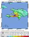
| Location | 18.457°N, 72.533°W |
| Depth | 13 km (8.1 miles) set by location program |
| Region | HAITI REGION |
| Distances | 25 km (15 miles) WSW of PORT-AU-PRINCE, Haiti 130 km (80 miles) E of Les Cayes, Haiti 150 km (95 miles) S of Cap-Haitien, Haiti 1125 km (700 miles) SE of Miami, Florida |
| Location Uncertainty | horizontal +/- 3.4 km (2.1 miles); depth fixed by location program |
| Parameters | NST=312, Nph=312, Dmin=143.7 km, Rmss=0.93 sec, Gp= 25°, M-type=teleseismic moment magnitude (Mw), Version=9 |
| Source |
|
| Event ID | us2010rja6 |
- This event has been reviewed by a seismologist.
- Did you feel it? Report shaking and damage at your location. You can also view a map displaying accumulated data from your report and others.
Earthquake Summary


Felt Reports
Severe damage and casualties in the Port-au-Prince area. Felt throughout Haiti and the Dominican Republic, in Turks and Caicos Islands, southeastern Cuba, eastern Jamaica, in parts of Puerto Rico and the Bahamas, and as far as Tampa, Florida and Caracas, Venezuela.
Tectonic Summary
The January 12, 2010, Haiti earthquake occurred in the boundary region separating the Caribbean plate and the North America plate. This plate boundary is dominated by left-lateral strike slip motion and compression, and accommodates about 20 mm/y slip, with the Caribbean plate moving eastward with respect to the North America plate.
Haiti occupies the western part of the island of Hispaniola, one of the Greater Antilles islands, situated between Puerto Rico and Cuba. At the longitude of the January 12 earthquake, motion between the Caribbean and North American plates is partitioned between two major east-west trending, strike-slip fault systems -- the Septentrional fault system in northern Haiti and the Enriquillo-Plantain Garden fault system in southern Haiti.
The location and focal mechanism of the earthquake are consistent with the event having occurred as left-lateral strike slip faulting on the Enriquillo-Plantain Garden fault system. This fault system accommodates about 7 mm/y, nearly half the overall motion between the Caribbean plate and North America plate.
The Enriquillo-Plantain Garden fault system has not produced a major earthquake in recent decades. The EPGFZ is the likely source of historical large earthquakes in 1860, 1770, 1761, 1751, 1684, 1673, and 1618, though none of these has been confirmed in the field as associated with this fault.
Earthquake Information for Caribbean
 Tsunami Information
- NOAA West Coast & Alaska Tsunami Warning Center
- NOAA Pacific Tsunami Warning Center
- The earthquake locations and magnitudes cited in these NOAA tsunami bulletins are very preliminary and may be superceded by USGS locations and magnitudes computed using more extensive data sets.
- Tsunami Information Links
Poster of the Seismicity of the Caribbean Plate and Vicinity
Earthquake Maps


Scientific & Technical Information

 Historic Moment Tensor Solutions
Additional Information, News Reports
- Preliminary Earthquake Report
- U.S. Geological Survey, National Earthquake Information Center:
World Data Center for Seismology, Denver
