Catholic Mission
Jordan Expedition
The Khirbat Iskandar Excavations
The overall project director since 1981 has been Dr. Suzanne Richard, Associate Professor at Gannon University, Erie, Pa. There have been 9 seasons of field excavation, research, and restoration work at the site of Khirbat Iskandar: full field excavations took place in 1982, 1984, 1987, 1997, and 2000; a pilot season of survey and soundings in 1981, a study season in 1994, a restoration and preservation season in 1998.
The project from the beginning has been approved by the Committee on Archaeological Policy (CAP) and affiliated with the American Schools of Oriental Research (ASOR). The project works closely with the American Center of Oriental Research (ACOR) in Amman, Jordan and operates under the guidance and by permit of the Department of Antiquities of the Hashemite Kingdom of Jordan. Currently, the project is sponsored by a consortium of three universities: Gannon University, Lubbock Christian University (LCU), and McMurry University. Dr. Suzanne Richard and Dr. Jesse C. Long, Jr. of Lubbock Christian University are co-directors of the archaeological project; Professor Bill Libby of McMurry University is co-director of the consortium.

Earlier excavation of the site took place in 1955, when Peter Parr of the British Institute in London excavated two trenches. Prior to that, Nelson Glueck explored the site and reported on it in his monumental work, Explorations in Eastern Palestine, 1939. He was the first to recognize the importance of Khirbat Iskandar for Early Bronze Age studies, especially the EB IV period.
Historical Background
Khirbat Iskandar is an Arabic name and means the "ruin of Alexander (the Great)." This name is taken from a modern village nearby; the original name of the site is unknown. The name is what archaeologists would call anachronistic, since Khirbat Iskandar is an Early Bronze Age site and Alexander the Great lived and conquered the area thousands of years later (323 BCE). The Early Bronze Age (EBA) dates to ca. 3500 - 2000 BCE, a 1500 hundred year era that saw the rise and collapse of the first cities. It is subdivided into four periods: EB I from 3500-3100; EB II from 3100-2700; EB III from 2700-2300; EB IV from 2300-2000.

The Early Bronze Age was a momentous period in the history of humankind. Why? Because it is the period of the first cities and the dawn of history: the time when writing was discovered. These great discoveries occurred in Mesopotamia and in Egypt. The "biblical lands" were greatly influenced by these advanced urban cultures to the north and south. Thus cities soon arose in Israel and Jordan as well, although evidence of writing is not found until the Middle Bronze Age, after 2000 BCE. The Early Bronze Age people were Canaanites and the land was called Canaan. You probably know the word from the Bible. The Canaanites occupied these lands before the Israelites arrived, around 1200 BCE.
The Early Bronze Age in the Near East is a period that can be distinguished from earlier times by a "leap" to cultural complexity. When people began to build cities, a great step occurred in human civilization. It is the very foundation of our own society today. The transition from hunter/gatherer to farmer was the first step in the development of settled life and it occurred much earlier (ca. 15,000 BCE). It was a long and gradual process, but as time went on life became more and more complex and the origin of cities was the result. There are many reasons why people would want or need to live in cities. As part of its research design, the Khirbat Iskandar project is exploring the development of cities and asking why cities suddenly disappear, as happened at the end of the EB III period in the southern Levant.
Location and Description
Look at the accompanying map to find Khirbat Iskandar. As you can see, it is east of the Dead Sea and south of the capital city of Amman, Jordan. It takes about an hour to drive there from Amman. The site sits on the north bank of the Wadi el Wala, at an important crossing point of a famous caravan route called the "King's Highway." The ancient inhabitants probably chose its location also because the wadi was a perennial river and an important source of water at that time.

Defense is always a consideration and so the city was built on a hill, which is why it is called Khirbat Iskandar and not Tell Iskander. Over 1500 years, the mound rose to a height of 20 meters (65 feet) as successive cities were built, destroyed and rebuilt. The mound gradually began to look more like a tell, as occupation built up over time. This buildup occurred because, unlike today, there were no bulldozers to clear the destroyed city before a new one was built. At an overall size of about 8 acres, Khirbat Iskandar is generally in the range of a medium-sized site.


We believe that in antiquity, a larger area was inhabited in the environs of the site, for a menhir stood across the wadi to the south, material remains were found by Glueck to the north and east of the site, and there are 3 cemeteries in the vicinity of the site as well.

Significance of Khirbat Iskandar

Khirbat Iskandar is often called the most important site in the EB IV period. It is because it appears to be a city that continued to survive after all the cities disappeared at the end of EB III. One of the trademarks of a city is usually its fortifications, and in EB IV Khirbat Iskandar had fortifications. They were the rebuilt defenses of the EB II-III period, but still unique as the only EB IV fortifications known thus far in the southern Levant. There is also a gateway as well as a public building that included many of the objects displayed in the museum exhibit.
 In comparison with the monumental cities of EB II-III, the EB IV settlement at Khirbat Iskandar was probably more of a town or regional center. The EB IV period is generally described as a "Dark Age" or a "Nomadic Interlude." That's because until recently mostly cemeteries had been excavated and not much was known about the culture. It was a time of far less cultural complexity than was the case during during the period of the great cities of EB II-III. Earlier archaeologists thought that nomads from Syria in the north had overrun the southern Levant and destroyed all the cities at the end of EB III. Therefore, all the people then reverted to a type of nomadism called pastoral nomadism until around 2000 BCE when cities rose up once again in the Middle Bronze Age.
Thanks to greater exploration, excavation, and survey over the past 20 years, our views on the EB IV have changed quite a bit. There probably was no invasion. Today archaeologists prefer to look not outside but within the culture itself to find the reasons for cultural change. All the people in the EB IV were not nomadic. Excavation demonstrates that there are, in fact, many sites known where people were permanently settled and lived primarily as farmers. These people traded agricultural produce with the pastoral nomads in exchange for meat and dairy products. This symbiotic relationship between nomads and settled people has always existed in the Near East. What is new is the knowledge that things didn't change even during a "Dark Age."
Everyday life in the Early Bronze Age at Khirbat Iskandar
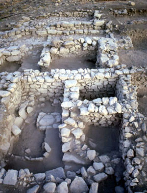
The last occupation on the mound is the best known. There are three subphases (EB IV A-C), but we will only discuss the very latest (A). In Area C there is an entryway or gateway that leads people into the upper town. In the photo you can see steps at the lower and at the upper end of the plastered passageway. The passageway is lined with stone benches. We know from biblical passages that "justice took place in the gate." Other ancient near eastern texts tell of trade and other types of activities. We don’t really know why there were benches at Khirbat Iskandar, but textual evidence provides some ideas. On either side are large structures that perhaps were "guardrooms," one of which was paved. We do know that there were work areas.


The remains found to the north of the upper steps indicate that the area was a courtyard. Off to the left there is a small stone bin, which had storage jars sitting on the pavement at one end. It is clear that by this stage of the Early Bronze Age, the 1500 year old culture was nearing its end. There was no huge fortification as previously. Rather, houses were strung together as a sort of defense across the mound with the Area C gateway the only way inside apparently. Along the east and western slopes of the mound we did find evidence for a rebuilt fortification that links to the EB IV site.
In square C6, a number of stone tables and benches were used for flintknapping. Throughout this area a great amount of flint debitage was found, along with ground stone objects for pounding and shaping flint cores into actual knives and other types of tools.

The photo of the flint knives shows a perfect example of what is known as a "Canaanean blade." It is worked on both sides. A number of these blades were placed inside a scythe or sickle tool, which was used to cut grain. Archaeologists know this because the blades usually have a patina or glossiness from contact with grains.
EB IV - Area B, Phase A

A very different kind of neighborhood came to light in the latest phase (A) in Area B. There we found a lot of evidence for the everyday life of people who must have walked through the gate in order to reach their homes at the northwest corner. Most of the buildings were strung together, that is they shared one or two walls with neighboring houses. Looking at the plan, we can see that the buildings could be "long-room" or "broad-room" houses. The structure in B1 is long, since as you enter, you see the length of the room; whereas, the doorway in B10 is on the long wall so that when you enter, the room appears to be broad, not long. Note that unlike B1, many of the buildings are subdivided into several rooms.

We may assume that, as in our very own homes, they had kitchens, sleeping rooms, work areas. Because the archaeologist saves everything during the excavation, it is possible to study the associations of materials and discover activity areas. For example, there was cooking activity found in B1, B2, B7, and B19 since excavation uncovered a tabun in each of those areas. The best associations of materials were found in B19. Near the tabun was a mortar used for grinding grain to make flour probably, and a large flat slab nearby probably served as a preparation surface for making the bread. Also in this room was a small bin, where vessels containing food and liquids were probably stored. We are calling this activity area a kitchen.
Further evidence for activities appeared in B11. This house was used for a different type of work than the preparation of food. Here we found a table with small depression next to a mortar set into the ground, as well as a large stone slab or table. These seem to be grinding installations. In the room a great deal of red powdery material was found in the surface, indicating that perhaps hematite or another material was being ground up and used as a coloring agent.
Note also that in this area and the next there is a row of pillars. Since pillars were not found in other houses, it is clear that they signify a different activity, perhaps status or wealth of the owner. It may reflect a type of courtyard house, where one half of the building was covered and the other open. In later periods, we know that small farm animals like sheep and goat might be stabled under the roofed section, while domestic activities took place in the courtyard and the people lived in another room or on a second floor.

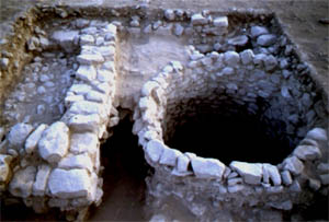
A few other different types of activities: in B2 there is a series of small bins dividing the space; it is difficult to know if they are for small animals or for work areas. There is a large courtyard in B5. From our excavations in 2000, unique stone-lined silos or wells appeared in B20 and B15. The B15 feature was 2.50 meter in diameter (close to 8’) and even deeper than that. In fact, by the end of the season we had not found the bottom yet. Excavation will continue in 2002.
Over all, in Phase A we have what appeared to have been a typical Early Bronze Age permanently settled community of people who were farmers, but who also owned flocks. It seems that the community was fairly self-sufficient, since evidence for various types of manufacturing processes was discovered. Although a potter's kiln has not yet been found, studies of the clays used in making the Khirbat Iskandar pottery suggest that the pottery was made locally.
In short, in a period when there is less complexity and fewer interrelations among sites, the people of a community have to do everything in order to survive. In the EB II-III, on the other hand, certain towns and cities would provide specialized objects for trade, the smaller farming communities would produce the grain for the cities, and pastoral-nomads would tend large flocks in order to trade meat and dairy products with the cities. The Phase A community at Khirbat Iskandar reflects the end of a 1500 year long civilization and a dying tradition. In 2000 BCE, it ends and the new vibrant Middle Bronze Age era begins.
EB IV - Area B, Phase B

Digging into earlier layers of the EB IV period has shown us that prior to Phase A, the community was more sophisticated, more complex, and more diverse.
How do we know this? Well, this settlement was enclosed by a strong defensive wall. In this area, rather than a series of domestic structures oriented north-south, we found a large public complex, that is, a number of rooms that all seemed to be part of one structure. The rooms run up to the fortifications, so it's much different from the last settlement (Phase A) above.
There is a large central room that has pillar bases. There were wooden beams  set on them holding up the roof. We know this because we found the remains of the beams. In the corner was an exceptionally well-made stone slab-lined basin. It contained many layers of seeds, grains, olives, and other remains. Through a doorway, one entered the bench-lined room next door. There were many vessels in this room, some found upside down in destruction debris. Remains of foods were found in some of the storejars. An entrance with steps was found in the main room. There was a pivot stone which indicates there was a doorway. The steps led into a corridor and presumably into other rooms of the building.
This structure is extremely important because most of the vessels on display at the Erie Art Museum were found in it. It is unlikely that a family would have over a hundred vessels in their house. This is why we think that this is a public building of some sort. It may have been a storeroom for the entire town. It may indicate that there were leaders or elites of the community who controlled the food and distributed it to the people.

It is also possible that there was a religious or cultic function or purpose to this structure, since many unusual things were found. For example, numerous miniature vessels were found near the stone basin. Often miniatures are used for libation purposes, that is the pouring of sacred liquids. Also, numerous pits were found in which there was a great deal of pottery that seems to have not been broken when placed in the pits. Oftentimes, vessels used in the cult are then buried in a sacred pit. We even found a decorated bowl that had in it the hoof of a bovine, perhaps the remnant of an offering. Goathorns were also found.
We are still studying the materials from this complex and we need further excavation to determine the purpose of this room. Our working hypothesis though is that it is a public complex, evidence for elites living and ruling at the site, and whose storerooms indicate either a cultic area, a redistribution center, or surpluses of food, liquids, oils used for trade.
This complex reflects a type of activity different from the later Phase A domestic houses found above. In Phase B we have not found tabuns for example, or much evidence for a variety of occupations and work in this area. That seems to indicate that people were more specialized in different areas of the mound, and perhaps in different towns and villages.
All of this seems to show that, at the beginning the EB IV, inhabitants continued the ways of the urban EB III peoples. Only toward the end, Phase A, did they drift into more of a village-type economy.
EB I/II/III - Area B, Phases C, D, E

Although the phasing at this point is very tentative, due to the small areas excavated, we do know that the site was occupied throughout the Early Bronze Age. The most recent excavations found a city below Phase B. It is not yet clear if the latter half of Phase C (there were two subphases) was a transition period from the urban period to EB IV. This is because pottery of EB IV was found in the upper layers.
What is clear is that the original Phase C people built very different structures of mudbrick on top of a stone wall. Some of the walls are still standing to 6' high. The photo of B2 shows a wall with doorway and threshold at the very bottom. Inside the room, there was a surface that led to steps. It is these steps that a person used to climb to the top of the tower to guard for enemies approaching the site. In B1, a portion of a room with pillar bases was found. In this room, smashed pottery was found lying on the surface, covered by roofing stones, mudbricks, beams and ash. As in the public complex in Phase B, this destruction material dates the structure, since this pottery was being used when the destruction occurred. The pottery needs to be studied, but it is from the urban EB II-III period.

Now that we have dug down far enough, it is clear that the huge fortifications at Khirbat Iskandar were first built in the urban EB II-III period. There is a very large square tower at the northwest corner. It connects to a 3 meter (10') high stone wall. There is even evidence that these fortifications originally included an inner mudbrick wall that was later strengthened. Overall the width of this combined wall was about 8 feet. It was very exciting in the dig this past summer to find a mudbrick fortification along the western edge of the mound. We think it originally went with the tower. This wall was destroyed in a fire. It was later covered by a new stone wall, which you can see in the top right of the photo.
We probed below the surface in B2 and found that two additional phases of architecture lay below. The pottery was very scant, but it appeared quite early, perhaps EB I-II. Thus, as you can see, there is much work yet to be done at Khirbat Iskandar in order to understand the earlier phases as well as we understand the EB IV phases A and B. In 2002 the expedition plans to expose more of Phase C horizontally in order to glimpse the nature of the urban settlement and thus be able to compare and contrast it with the non-urban EB IV settlements.
Cemeteries

As mentioned above, there are numerous cemeteries in the vicinity of Khirbat Iskandar. To the east is cemetery E, to the west is Cemetery J, and across the wadi to the south is cemetery D. Mostly the project has excavated EB IV shaft tombs. In the EB IV period, people did not bury their dead in huge caves as the urban people did. In big cities with large populations, the custom seems to be that there are family tombs used over long periods of time. Some caves have hundreds of burials. The EB IV people did not live in cities; oftentime they were in small villages far from any other site. There were a lot of pastoralists too and it is possible that their traditions dominate in this period.

In the chamber of the shaft tomb E6, we found evidence for multiple burials along with pottery and objects. Tomb E3, however, was small and only had a pile of bones around which were four vessels. We have not found any burial evidence for the EB II-III period, although there are a number of robbed caves that we investigated in the hillside across the wadi to the south.
In Cemetery J to the west, one EB I tomb was found. It was very different from either of the two types of burial customs mentioned. This was a cist tomb that was dug into the ground and then covered with stones. In it were many bone fragments and typical EB I pottery like the duck-bill storejar on display at the Museum, as well as the small cup with high handle, which was used as a dipper juglet for dipping out water.
Copyright © 2005 Suzanne Richard
109 University Square • Erie, Pennsylvania 16541-0001 (Get Directions)
1-800 GANNON-U (1-800-426-6668) or 814-871-7000
Web site Powered by ActiveCampus™ Software by LiquidMatrix