The Chihuahuan Desert
Boundaries | Water in the Chihuahuan | Desertification
Welcome to the Chihuahuan Desert
The Chihuahuan Desert is the easternmost, southernmost, and largest North American desert. Most of it is located in the states of Chihuahua and Coahuila in Mexico, but fingers of the Chihuahuan reach up into western Arizona, southern New Mexico, and Texas, and down to the states of Zacatecas, and San Luis Potosi in Mexico. This desert is quite large - about 175,000 square miles - making it bigger than the entire state of California.
The Chihuahuan is usually called a rain shadow desert. That is because two massive mountain ranges, the Sierra Madre Occidental on the west and the Sierra Madre Oriental on the east, border the Mexican portion of the Chihuahuan. These mountains block most of the moisture from the Gulf of Mexico and the Pacific Ocean from reaching the land, and are the main reason that this desert developed. One important characteristic of the Chihuahuan Desert is the many small mountain ranges which run through it, including the Franklins in Texas, and the San Andres and Doña Anas in New Mexico. Between these mountains are valleys of lower elevation. In fact, the elevation changes in the Chihuahuan from about 1970 feet to about 5500 feet above sea level. There are also river valleys, formed by the Rio Grande and the Pecos rivers, creating large riparian areas within the desert. The presence of these river valleys and the changes in elevation produce a variety of habitats in the Chihuahuan that are not present in many other deserts. This means that diverse plants and animals can live within its boundaries. For example, in Big Bend in Texas where the elevation is low, there are many lizards which could not survive the cool winters of the desert mountains. And although fish are usually not thought of as desert dwellers, there are many in the Chihuahuan's aquatic habitats.
Boundaries
So how do we tell where the Chihuahuan Desert ends if there are so many habitats within it?

As in every desert, there are certain plants or animals that appear throughout the whole Chihuahuan and are called indicator species - in other words they indicate when you are in that desert. You are probably thinking that these indicators are cacti, because the neighboring Sonoran desert, is so famous for its saguaro cacti. Sorry to disappoint you, but this is not so in the Chihuahuan. Although barrel cacti and prickly pear grow in many parts of the desert, the real indicators are the Chihuahuan shrubs such as creosotebush, mesquite, agave, and ocotillo. There is only one plant that is endemic to the Chihuahuan Desert - meaning that it doesn't grow anywhere else - and it is called lechugilla, a kind of agave. All of these indicator species disappear in Socorro, New Mexico. So we usually think of Socorro as the northernmost point of the Chihuahuan Desert.
Water in the Chihuahuan
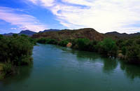
Photo by V. Espinoza
The Chihuahuan Desert is a fairly dry desert, with only one intense rainy season in the summer, and mild rains in the early winter, usually in December. The summer rains, occurring in June and July, are called monsoons, and are caused by moist air that penetrates from the Gulf of Mexico. But living creatures need water during the entire year, and as in most deserts, it comes from several sources. The Rio Grande runs right through the center of the desert in New Mexico and serves as the border between Chihuahua, Mexico and Texas. The river provides riparian habitat for cottonwood and other trees, birds, and land animals, and homes for fish. It is also an important center for human development and a source of water for irrigating croplands.

Photo by G. Morris Southward
Other important sources of water for many animal and plant species are the ephemeral streams, lakes, arroyos, and even large puddles that form during the summer monsoons. And there is water underneath the desert that has seeped down over centuries from the surface. How deep and how much water there is depends on where in the desert you are located. For example, in the Mesilla Valley where the Rio Grande runs, there are large amounts of water in an aquifer that is only 15-20 feet under the surface. However, mountainous areas of the desert, or valleys that do not contain rivers often have their water as far down as 200-700 feet below the surface. In these places, pumping water is more difficult, and the water does not replenish nearly as fast as in the river valleys.
There are some interesting results of having this sub-surface water in the Chihuahuan Desert, and one of these is the presence of oases. An oasis is a fertile area of the desert usually caused by the springing up of water from below. Oases provide habitats for many species of animals and plants that could not usually survive under desert conditions. The most famous oasis in the Chihuahuan Desert is in Cuatro Ciénegas Basin in Mexico. It has schools of fish, aquatic turtles, and other unusual residents of its many pools, lakes and canals. People even go snorkeling there!
Desertification - How the Chihuahuan Desert Has Changed
Although there have been deserts in this location in North America several times between the ice ages, this particular desert that we call the Chihuahuan has only been in existence for about 8000 years. That may sound like forever, but when you think of how long ago the dinosaurs lived (over 125 million years ago), 8000 years makes this desert a youngster in geologic terms. The Chihuahuan has been through many changes during its history and particularly in the last 150 years. In the 1850s, the grass in the northern Chihuahuan Desert was said to grow as high as the belly of a horse. Since then, a process called desertification has been taking place very quickly. Lands that were once desert grasslands are now almost all shrub desert with the grasses fast disappearing. And this is affecting and being affected by all desert life because it is all one ecological system.
There are several reasons for this desertification. Before technology was developed to dig cost-effective deep wells, the grazing in the northern Chihuahuan Desert was limited to small herds. However, about 150 years ago, people began to access water more easily, and large herds of cattle were brought in. Because people did not yet understand the effects the cattle might have, they did not manage this grazing well until years had passed. By then the large herds had trampled and eaten the grasses, causing patchy areas without vegetation which allowed the shrubs to move in. This is often called the shrub invasion. And once this process began, it continued with the help of other animals like kangaroo rats and jackrabbits.

Photo by G. Morris Southward
Actually, desertification started long ago in the southern Chihuahuan Desert because there had been grazing in Mexico much longer than in the US. And there are places in the Middle East where desertification has been slowly happening for thousands of years. Many people think that the earth's climate is gradually drying out, so that eventually desertification would have happened anyway. We really have no way of knowing. But when you add the animal grazing to the changes in global climate you get different desert plants. There are now few desert grasslands left throughout the world, and almost none in the Chihuahuan Desert.
References
1996 Grolier Multimedia Encyclopedia (Version 8.1 S) [CD-ROM]. Grolier Electronic Publishing.
Grall, G. (1995, October). Cuatro Ciénegas: Mexico's desert aquarium. In National Geographic, 188 (4), 84-97.
Kirk, R. (1973). Desert: The American southwest. Boston: Houghton Mifflin.
Desert USA, Digital West Media, Inc. (1996, August 15). Chihuahuan desert [On-line]. Available: Internet: http://www.desertusa.com/du_chihuan.html.
Jornada LTER. (1996, August 15). Jornada experimental range [On-line]. Available: Internet: http://atlantic.evsc.virginia.edu/regionalization/jrn.html.
Seager, W. Geology Department, New Mexico State University (personal communication with Sandra Bolotsky, July, 1996).
Sherbrooke, W. C. (1981). Horned lizards: Unique reptiles of western North America. Globe, AZ: Southwest Parks and Monuments Asssociation.
Van Cleve, K., & Martin, S. (Eds.). (1991). Long-term ecological research in the United States (6th ed.). Seattle, WA: Long-Term Ecological Research Network Office, University of Washington.
Whitford, W., Jornada Range Experimental Research (personal communication with Sandra Bolotsky, July, 1996).
Zimmer, C. (1995. February). How to make a desert. Discover.
University of Texas at El Paso Centennial Museum's Laboratory for Environmental Biology. (1996, August 15).Chihuahuan desert region [On-line]. Available: Internet: http://museum.utep.edu/chih/chihdes.htm