


(Cooperative Institute for Research in the Atmosphere)
The lives and livelihoods of millions of people along India’s east coast are in peril as monstrous cyclone Phailin makes its approach from the Bay of Bengal. Phailin – a Thai word for ‘sapphire’ – has estimated maximum sustained winds of around 160 mph, ranking among the most intense cyclones to threaten India on record.
(Cyclones have the same characteristics as hurricanes and typhoons – but these same storms have different nomenclature in different parts of the world.)
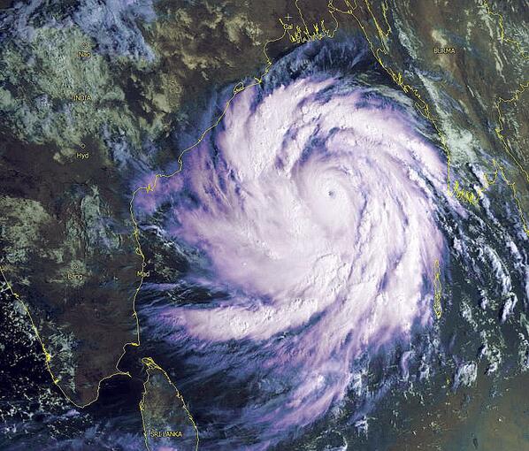
The ferocious storm, whose rain bands are already cycling inland, is about 24 hours from landfall. It is expected to come ashore late afternoon or early evening local time on Saturday (or early morning EDT) in northeast India between approximately Visakhapatnam and Puri.

Phailin track forecast (Joint Typhoon Warning Center)
Link: Radar loops for Phailin
Very ominously, after its core re-organized overnight, Phailin is once again strengthening.
After eyewall replacement, #Phailin bigger and meaner –intensifying again. pic.twitter.com/L7tVJSWKEr
— Ryan Maue (@RyanMaue) October 11, 2013
The storm is the equivalent of a category 5 hurricane, which comes with these kinds of impacts, according to the National Hurricane Center:
A high percentage of framed homes will be destroyed, with total roof failure and wall collapse. Fallen trees and power poles will isolate residential areas. Power outages will last for weeks to possibly months. Most of the area will be uninhabitable for weeks or months.
“A Category 5 (equivalent) landfall on that region will be unimaginable,” says Brian McNoldy, Capital Weather Gang tropical weather expert.
By far, the greatest threat from Phailin is its storm surge. When the storm makes a landfall, it is likely to push ashore a devastating wall of water up to 20 feet high just north of its center, inundating vast, highly-populated areas.
A storm surge disaster is practically unavoidable writes Hal Needham, a research climatologist and storm surge specialist on staff at Louisiana State University.
“The storm conditions 18 hours before landfall tend to correlate best with storm surge heights,” writes Needham. “This means essentially that a catastrophic storm surge is a certainty given the forecast intensity and size at 18 hours before landfall”
Needham adds: “Tropical Cyclone Phailin has the potential to generate a surge at least 6 meters (20 feet) high. This surge height would be comparable to the storm surge generated by the Galveston Hurricane of 1900. This storm devastated Galveston Island, Texas, killing between 6,000 and 8,000 people in the deadliest natural disaster in U.S. history.”
Even more than the Gulf of Mexico, the Bay of Bengal promotes dangerous storm surges due to its densely-populated coastline and the combination of its semi-enclosed shape and shallow depth, which increases the height of inbound water.
“The Bay of Bengal has been the home of the most catastrophic storm surge disasters on the planet,” writes Needham.
26 of the world’s 35 deadliest tropical storms have formed in the Bay of Bengal, as I noted yesterday.
The 1999 Odisha cyclone, which followed a similar path to Phailin, generated a surge exceeding 20 feet. That storm killed about 15,000 people and left over 1.6 million people homeless.
Writes the UK Met Office: “[Phailin] is likely to be the strongest cyclone to hit India since the devastating ‘Odisha Cyclone’ of 1999, and it is possible it could be even stronger.”
In addition to the destructive winds and storm surge, torrential rains – capable of producing freshwater flooding and mudslides – are likely.
IMD: Nearly one meter of rain could fall across Eastern India after #Phailin makes landfall. pic.twitter.com/Tgt1LNhiUr
— Eric Holthaus (@EricHolthaus) October 11, 2013
The Indian government has mobilized a large preparation and response effort in advance of the storm, reports the Wall Street Journal.
“The National Disaster Response Force has formed 28 teams, comprising a total of 1,000 people, to carry out evacuation operations as well as for any rescue or relief work,” The Journal writes.
Video: Indian villagers evacuate ahead of cyclone Phailin
Given the grave threat posed by the storm surge, Needwood stresses the urgent need for evacuations.
“All people in the coastal zone near and to the northeast of the landfall location should be evacuated immediately,” he writes.
On a more optimistic note, wunderground meteorologist Jeff Masters predicts Phailin to make landfall about 100 miles to the southwest of where Odisha came ashore in 1999.
“This region of the coast is not as low-lying, which should keep the death toll due to storm surge much lower compared to the 1999 Odisha Cyclone, where more than 70% of the deaths occurred due to the storm surge,” Masters writes.
RELATED: Extreme weather of 2013


