Feedback on the plans for Heathcote to the Central City through Opawa, Woolston and Waltham closed 12pm Friday 23 December 2016.

MCR Heathcote Banner

Background

Starting from Martindales Road in Heathcote Valley the Heathcote Expressway runs roughly parallel to the Lyttelton Line railway tracks on its way to the Central City. It connects Heathcote, Ferrymead and Woolston as well as key destinations such as Ferrymead Historic Park, The Tannery and Ara.

Engagement Advisor contact details:

Rochelle Hardy: (03) 371 2037
Katherine Eveleigh: (03) 375 1325
Email: cycleways@ccc.govt.nz

Route Selection

In developing the Heathcote Expressway Council staff and technical experts from external agencies considered a number of different routes and types of cycleways. The route shown on this page provides the best connection to local amenities, schools and businesses, while maintaining a reasonably direct route for people biking to and from the Central City, and minimising the impact on adjacent properties.

Assessing the options
There are a number of factors that determine the best route for a cycleway including safety, compatibility with other road users and impacts on residents and businesses.

For Heathcote Expressway, various route options were initially identified and assessed against multiple criteria designed
to provide a balance between the needs of people wanting to cycle and the impacts of the cycleway on businesses, residents and the road network. The following provides information on some of the criteria used when assessing the route options:

  • Safety first

For the cycleways to work well and feel safe, the Major CycleRoutes must be built in a certain way. This means separating people on bikes from motor vehicles in some areas or slowing vehicle speeds and reducing vehicle numbers in others.

Generally, the preferred location for a Major Cycle Route is on quieter streets where there are less large vehicles such as trucks. However, this needs to be balanced against providing direct routes and linking with local amenities such as shops, schools and parks.

When assessing safety, consideration has also been given to creating quality environments that feel safe and attractive,
including design aspects such as lighting, landscaping and surrounding activity so that the route feels comfortable and safe for all users.

  • Traffic network considerations

Building safe cycle routes is one way to make a sustainable and reliable transport network. Where the proposed cycle route significantly changes the road, it is important to assess whether there will be an impact on the rest of the transport network. In some cases, plans for the route need to be changed to avoid causing significant delays or congestion elsewhere.

  • Business Impacts

The Council recognises that existing parking and access to businesses is very important, particularly for local shops which rely on passing custom. We have retained existing parking where possible, however with limited road space this is not always possible. Parking surveys have been undertaken at key locations to understand the current parking demand and consideration has been given to alternative on-street parking close by where applicable.

Parking spaces will be removed in various places along the route to make room for the new cycle facilities. Parks will be lost along Ferry Road, Wilsons Road, Charles Street, Cumnor Terrace and Truscotts Road (see the plans and descriptions for further details).

  • Residential Impacts

The Council is aware of the need to balance different residents travel needs, including access and parking. We have carefully considered options to keep as much parking as possible. However, when planning safe, direct cycleways using limited available space there will be times when vehicle parking does not take priority.

  • Landscaping

In some areas we will need to remove trees to make room for the cycleways. Where appropriate, trees to be removed will be replaced in suitable locations nearby.

  • Rubbish collection and street cleaning

Building a safe cycleway will require changes to some service operations along the route. For example, street cleaning will be different along the new cycleway. Rubbish collection will also change for some residents and businesses. If you have on-street parking outside your property, there will be space next to the cycleway separator island for your wheelie bins (you will get more information about this as the project progresses). Where there is no on-street parking, residents and businesses will continue with their current roadside collection.

Along the whole route 53 trees have been identified that will need to be removed. Approximately 140 replacement trees will be planted close by and various additional new trees are proposed along the route. The exact location of new trees are indicative on the plans and will be confirmed during detailed design.

The Heathcote Expressway will connect with a cycleway on Ferry Road as part of the An Accessible City transport programme. More information on the An Accessible City projects are available at ccc.govt.nz/aactransportprojects

Read the detailed Heathcote Expressway Assessment Report (PDF).


Route Description

The route options for each section of the cycleways have been assessed against the criteria set out on previous pages. The aim is to determine the best route for each section, while keeping in mind how sections fit together to form a continuous and clear route.

Preferred Route Options

Click to enlarge.

The Heathcote Expressway route connects the Central City to Heathcote. The route starts at the Fitzgerald Avenue/Ferry Road intersection and ends at Martindales Road in Heathcote. From Fitzgerald Avenue heading into the city, the cycleway will join the separated cycleways proposed as part of the planned An Accessible City programme.

At the Heathcote end of the route, opportunities have been identified to extend the cycleway to other points of interest in the Heathcote Valley. These may be considered at a later date.

Section A: Ferry Road & Wilsons Road (0.9km from Fitzgerald Ave to Charles St)

Preferred Route: The preferred Heathcote Expressway route starts at the Fitzgerald Avenue/Ferry Road intersection, travels along Ferry Road through the Ferry Road/Moorhouse Avenue signalised intersection and continues down Wilsons Road to Charles Street. The cycle way will be built as separatedcycle lanes on each side of the road, protected from traffic by separator islands.

Other options considered: A route along Fitzgerald Avenue, Moorhouse Avenue, the rail corridor and Lismore Street was considered (shown in green). Fitzgerald Avenue and Moorhouse Avenue would be significantly longer in length, and less direct and therefore less likely to be used. Additionally the rail corridor is very isolated, so people may feel unsafe using this route, particularly after dark. Falsgrave Street (shown in blue) was also considered, but this is also isolated, so people may feel unsafe using this route, particularly after dark.

Section B: Charles Street, Mackenzie Ave and Sheldon St (2.1km from Wilsons Rd to Cumnor Tce)

Preferred Route: The preferred route is for cyclists to share the road with general road traffic along Charles Street, Mackenzie Avenue and Sheldon Street. New signalised pedestrian and cyclist crossings will be built across Wilsons Road and Ensors Road. A wider bridge will also replace the existing footbridge over the Heathcote River between Mackenzie Ave and Sheldon Street. This route is considered pleasant, direct and well connected to the surrounding area.
Other options considered: A route using the rail corridor was considered (shown in red). This option has limited connectivity to the surrounding area, with long isolated sections, makingit difficult for cyclists or pedestrians to get off the path, should they feel unsafe.

A route along Opawa Road (shown in green) was also considered and would provide additional connection to businesses, schools and residents south of Brougham Street. However there are a number of busy intersections and safety concerns, which would be costly to overcome. Because of the lack of space, a significant number of car parks would need to be removed.

A route along Brougham Street (State Highway 76) (shown in blue) was also considered. However, New Zealand Transport Agency have long term plans to widen this to four lanes making space limited at key locations.

Section C: Cumnor Terrace (1.9km from Sheldon Street to Chapmans Road)
Preferred Route: The preferred route is a shared cycle and pedestrian path adjacent to the Heathcote Riverbank. A new signalised pedestrian and cyclist crossing will be built on Garlands Road (State Highway 74A) next to the Tannery. This riverside route is pleasant and connects well to The Tannery.

Other options considered: A route using Garlands Road and Maunsell Street was considered (shown in green). This option has significant safety concerns with busy intersections and vehicle entrances used by large trucks and other heavy vehicles.

A route along King Edward Terrace and the northern riverbank was also considered (shown in dashed purple along Cumnor Terrace). This option requires significant and expensive riverbank works, including a new bridge. The area along the river bank is also isolated and people may feel unsafe using this route, particularly at night. 

A route further south following Opawa Road and Port Hills Road (State Highway 76) was also considered (shown in blue). There are many heavy vehicle entrances on the north side of State Highway 76 as it provides access to the Port Depot and industrial area. To make this option work a shared path would need to be constructed on the south side of the State Highway for safety. This option was considered too expensive and disruptive to the freight road corridor.

Section D: Kennaway Park, Tunnel Rd and Ferrymead Park (1.9km from Chapmans to Truscotts Rd)
Preferred Route: The preferred route is a shared cycleway and pedestrian path through Kennaway Park. It then follows the wide berm along Tunnel Road (State Highway 74) and land beside Ferrymead Heritage Park. This will provide a safe, pleasant cycling experience with minimal interaction with vehicles. It also provides good access to activities at Ferrymead.

Other options considered: A route using Chapmans Road, Kennaway Road and Dalziel Place (shown in green) is a shorter distance than the preferred route. However, this was considered less safe and less attractive than the preferred option. Cyclists would need to turn at various intersections and cross a number of vehicle entrances in an area where there is a significant volume of heavy vehicles.

The KiwiRail corridor, east of Tunnel Road, was also considered (shown in red adjacent to the preferred route). The south side of the rail tracks is isolated and people may feel unsafe using this route particularly at night. The north side of the track was also considered but there were space limitations.

A route along Port Hills Road east of Tunnel Road (shown in blue) was considered, whilst this provides improved residential connections the road is very narrow and potentially unsafe, particularly at the Martindales Road roundabout.

Section E: Truscotts Road (0.5km from Ferrymead Park Drive to Martindales Road)
Preferred Route: The preferred route is for cyclists to share the road with general traffic along Truscotts Road. A new pedestrian footpath will also be built between the new shared path at the back of Ferrymead Heritage Park to connect with Deavoll Place. This route is direct and provides a pleasant rural outlook. The Heathcote Expressway Major Cycle Route finishes at Martindales Road.

Full plans

Ferry Road - Wilsons Road

Ferry Road (Ferry Road / Fitzgerald Avenue Intersection)

 Key features of the proposed cycleway on this section of Ferry Road

Click to enlarge.

Key features of the proposed cycleway on this section of Ferry Road include:

  • Crossing: The existing traffic signals at Fitzgerald Avenue and Ferry Road will be upgraded to include a green cyclist traffic light symbol.
  • Cycle Lanes FerryRoad: New 2.1m wide cycle lanes are proposed on both sides of Ferry Road, separated from traffic by a solid kerb, replacing existing painted cycle lanes.
  • Cycle Lanes Fitzgerald Avenue: New, painted cycle lanes on Fitzgerald Avenue will allow people to get on and off the major cycleway route along Ferry Road.
  • Cyclist Right Turn: Cyclists turning right will cross the intersection in two stages. The ‘hook turn’ box will provide a space for them to wait between each crossing stage.
  • Right Turn Ban: Vehicles will not be able to turn right from Ferry Road to Fitzgerald Avenue heading south. Drivers wanting to turn right will need to use Barbadoes Street and Moorhouse Avenue.
  • Left Turn Ban: Vehicles will not be able to turn left from Ferry Road to Fitzgerald Avenue heading south. Vehicles wanting to turn will need to use Moorhouse Avenue.
  • Pedestrians: The existing pedestrian crossing will be upgraded to cross Fitzgerald Avenue in two stages, using the median berm area to wait if needed.
  • Trees: Four trees will need to be removed in the central median. Replacement trees will be planted.

Along Ferry Road where separated cycleways are proposed, on-street parking is reduced by approximately 90%.

At the Ferry Road/Fitzgerald Avenue intersection vehicles will not be able to turn right from the western side of Ferry Road onto Fitzgerald Avenue or left from the eastern side of Ferry Road onto Fitzgerald Avenue.

Ferry Road

 Key features of the proposed cycleway on this section of Ferry Road

Click to enlarge.

Key features of the proposed cycleway on this section of Ferry Road include:

  • Cycle Lanes Ferry Road: New 2.1m wide cycle lanes are proposed on both side of Ferry Road protected from traffic by a separator.
  • Parking North Side: On-street parking will need to be removed from the north side at Ferry Road
  • Parking South Side: On-street parking will be reconfigured on the south side of Ferry Road so drivers entering and exiting driveways can clearly see people on bikes.
  • Bus Stop: The bus stop will remain in the same location but be moved out from the cycle lane.
Artists impression

Click to enlarge.

Ferry Road (Phillips Street – Lancaster Street)

Key features of the proposed cycleway on this section of Ferry Road

Click to enlarge.

Key features of the proposed cycleway on this section of Ferry Road include:

  • Cycle Lanes Ferry Road: New 2.1m wide cycle lanes are proposed on both sides of Ferry Road protected from traffic by a separator.
  • Parking: On-street parking will need to be removed from both sides of Ferry Road.
  • Bus Stop: The bus stop will remain in its current location.
  • Phillips Street: At Phillips Street, a raised platform will be installed with give way signs on entry to Ferry Road.A pedestrian island will allow pedestrians to safely cross the road.
  • Lancaster Street: At Lancaster Street a raised platform will be installed with give way signs on entry to Ferry Road. The existing pedestrian island will be moved so pedestrians can cross safely.
 Before and after

Click to enlarge.

Ferry Road – Wilsons Road (Moorhouse Avenue – Nursery Road)

 Key features of the proposed cycleway on this section of Ferry Road

Click to enlarge.

Key features of the proposed cycleway on this section of Ferry Road – Wilsons Road (Moorhouse Avenue – Nursery Road):

  • Crossing: The traffic signals at the Ferry Road/Moorhouse Avenue/Wilsons Road intersection, will be upgraded to include a cyclist crossing phase.
  • Moorhouse Ave west and Ferry Road east: There is a separate road widening project proposed along Moorhouse Avenue and Ferry Road, the details of whichare not shown in these consultation plans. Consultation on these plans will occur separately.
  • Cycle Lanes Ferry Road: From Ferry Road the 2.1m separated cycle lane will go across the existing berm area to the Ferry Road intersection.
  • Cycle Lanes Wilsons Road: Along Wilsons Road the 2.1m wide cycle lane is protected from traffic by a separator.
  • Pedestrians: The existing pedestrian crossing will be changed to fit the new intersection layout.
  • Trees: Three trees will be removed and replaced with two new trees.
  • Cyclist Right Turn: Cyclists travelling west along Ferry Road will cross the Moorhouse Avenue intersection in two stages. The ‘hook turn’ box will provide a space for themto wait between each crossing stage.
  • Ban left turn: Vehicles will not be able to turn left from Wilsons Road to Moorhouse Avenue.
  • Ban right turn: Vehicles will not be able to turn right from Ferry Road into Nursery Road.

At Ferry Road/Nursery Road intersection vehicles will not be able to turn right from Ferry Road into Nursery Road.

At Ferry Road/Moorhouse Avenue/Wilsons Road intersection vehicles will not be able to turn left from Wilsons Road to Moorhouse Avenue.

Wilsons Road (Stevens Street)

Key features of the proposed cycleway on Wilsons Road (Stevens Street)

Click to enlarge.

Key features of the proposed cycleway on Wilsons Road (Stevens Street):

  • Cycle Lanes: On Wilsons Road the 2.1m wide cycle lane is protected from traffic by a separator.
  • Shared Path: South of Stevens Street a shared pedestrian and cycle path is proposed.
  • Stevens Street: At Stevens Street a raised platform will be installed with give way signs on entry to Wilsons Road.
  • Parking East Side: On-street parking will be removed from the east side.
  • Parking West Side: On-street parking will be removed north of Stevens Street but remain south of Stevens Street.
  • Tree removal: One tree will need to be removed.

Along Wilsons Road where separated cycleways are proposed, on-street parking will be provided on the west side only, reducing the parking by approximately 50%.

Artists Impression

Click to enlarge.


Wilsons Road - Mackenzie Avenue

Wilsons Road – Charles Street (Barbour Street)


 Key features of the proposed cycleway on this section of Wilsons Rd – Charles St

Click to enlarge.

Key features of the proposed cycleway on this section of Wilsons Road – Charles Street (Barbour Street):

  • Cycle Lanes: On the east side of Wilsons Road a 2.1m wide cycle lane will be protected from traffic by a separator.
  • Shared Path: On the west side of Wilsons Road a shared pedestrian and cycle path is proposed.
  • Wilson Street Crossing: At Charles Street a new signalised crossing will allow pedestrians and cyclists to safely cross Wilsons Road onto Charles Street.
  • Charles Street Crossing: A raised platform will provide a crossing at the western end of Charles Street for cyclists to get on and off the cycle path.
  • Share the Road: Along Charles Street cyclists will share the road with general traffic. Road markings will indicate to drivers that this is a shared space.
  • Speed Limit: A 30km/hr speed limit on Charles Street provides a safer environment for people to travel by bike.
  • Give Way: The give way on Charles Street will be removed so that cyclists have priority.
  • Trees: Trees will be planted at various locations along the Charles Street.
  • Tree removal: Four trees will need to be removed.

Trees will be planted in the road space to narrow the street and slow traffic.

Charles Street (Grafton Street)

 Key features of the proposed cycleway on this section of Charles St (Grafton St)

Click to enlarge.

Key features of the proposed cycleway on this section of Charles Street (Grafton Street):

  • Share the Road: Vehicles will share the road with cyclists along Charles Street. Road markings will indicate to drivers that this is a shared space.
  • Speed Limit: A 30km/hr speed limit on Charles Street provides a safer environment for people to travel by bike.
  • Give Way: The give way will be removed to give all traffic on Charles Street priority. The give way will be shifted to Grafton Street.
  • Raised Platform: A raised platform will reinforce the slow speed environment.
  • Trees: Trees will be planted along the Charles Street.

The speed limit will be reduced to 30km/ hr along the cycleway on Charles Street, Mackenzie Avenue and Sheldon Street.

 Artists Impressions

Click to enlarge.

Charles Street (Osborne Street)

 Key features of the proposed cycleway on this section of Charles St (Osborne St)

Click to enlarge.

Key features of the proposed cycleway on this section of Charles Street (Osborne Street):

  • Share the Road: Vehicles will share the road with cyclists along Charles Street. Road markings will show drivers that this is a shared space.
  • Speed Limit: A 30km/hr speed limit on Charles Street provides a safer environment for people to travel by bike.
  • Give Way: The give way will be removed to give all traffic on Charles Street priority. The give way will be shifted to Osborne Street.
  • Raised Platform: A raised platform will reinforce the slow speed environment.
  • Trees: Trees will be planted at various locations along Charles Street, which will further reinforce the street as a slow speed environment.
  • Road Humps: Road humps on Osborne Street will slow vehicles down, on entry to Charles Street.

Charles Street - Mackenzie Avenue (Ensors Road)

 Key features of the proposed cycleway on this section of Charles St

Click to enlarge.

Key features of the proposed cycleway on this section of Charles Street - Mackenzie Avenue (Ensors Road):

  • Cycle Crossing: A new signalised crossing will allow cyclists to safely cross Ensors Road.
  • Cycle Path: The existing path will be widened between Charles Street and the new signalised crossing.
  • Pedestrian Crossing: A new signalised crossing will cross pedestrians over Ensors Road in two stages.
  • Pedestrian Path: The existing footpath will provide access for pedestrians from the Charles Street cul-de-sac to the new signalised crossing.
  • Trees: Five trees will need to be removed.
  • Shared Path: A shared path will connect to Mackenzie Avenue.
  • Speed Limit: The speed limit on Mackenzie Avenue will be lowered to 30km/hr to provide a safer environment for people to travel by bike.
  • Pedestrian Island: The existing road hump will be removed and a new traffic island built to allow pedestrians to cross Mackenzie Avenue.
  • Raised Platform: A new raised platform will be builtto reinforce the slow speed environment and provide a crossing for people on bikes to get on and off the shared path.
  • Banned Turn: Vehicles will not be able to turn right from Mackenzie Avenue onto Ensors Road.

At the Ensors Road/Mackenzie Avenue intersection vehicles will not be able to turn right from Mackenzie Avenue into Ensors Road.

Along Charles Street, Mackenzie Avenue and Sheldon Street where vehicles will share the road with cyclists, on-street parking will be reduced. Traffic calming measures such as raised platforms and on-street planters are proposed.

Mackenzie Avenue (Arthurson Mews)

 Key features of the proposed cycleway on this section of Mackenzie Avenue

Click to enlarge.

Key features of the proposed cycleway on this section of Mackenzie Avenue:

  • Share the Road: On Mackenzie Avenue, cyclists will share with general traffic. Road markings will show drivers that this is a shared space. The speed limit will be reducedto 30km/hr to provide a safer environment for people to travel by bike.
  • Raised Platform: Raised platforms will be built to reinforce the slow speed environment.
  • Trees: Trees will be planted at various locations along Mackenzie Avenue.


Mackenzie Avenue - Sheldon Street

Mackenzie Avenue (Vintners Lane – Bluebell Lane)

 Key features of the proposed cycleway on this section of Mackenzie Avenue

Click to enlarge.

Key features of the proposed cycleway on this section of Mackenzie Avenue:

  • Share the Road: On Mackenzie Avenue cyclists will share the road with general traffic. Road markings will indicate to drivers that this is a shared space. The speed limit willbe reduced to 30km/hr to provide a safer environment for people who travel by bike.
  • Raised Platform: Raised platforms will be built to reinforce the slow speed environment.
  • Trees: Trees will be planted at various locations along Mackenzie Avenue.

Mackenzie Avenue (Finlay Place – Hopkins Street – Keswick Street)

Key features of the proposed cycleway on this section of Mackenzie Avenue

Click to enlarge.

Key features of the proposed cycleway on this section of Mackenzie Avenue (Finlay Place – Hopkins Street – Keswick Street):

  • Share the Road: On Mackenzie Avenue cyclists will share the road with general road traffic. Road markings will indicate to drivers that this is a shared space.
  • Speed Limit: The speed limit will be reduced to 30km/hr to provide a safer environment for people who travel by bike.
  • Raised Platform: A raised platform at the Hopkins and Finlay Place intersections will reinforce the slow speed environment.
  • Trees: Trees will be planted at various locations along Mackenzie Avenue.
 Before and After

Click to enlarge.

Mackenzie Avenue (Palamino Place – Seaforth Place)

 Key features of the proposed cycleway on this section of Mackenzie Avenue

Click to enlarge.

Key features of the proposed cycleway on this section of Mackenzie Avenue (Palamino Place – Seaforth Place):

  • Share the Road: On Mackenzie Avenue cyclists will share the road with general road traffic. Road markings will indicate to drivers that this is a shared space.
  • Speed Limit: The speed limit will be reduced to 30km/hr to provide a safer environment for people who travel by bike.
  • Raised Platform: Raised platforms at Palamino Place and Seaforth Place intersections will reinforce the slow speed environment.
  • Trees: New trees will be planted at various locations along Mackenzie Avenue.
 Artists Impression

Click to enlarge.

Mackenzie Avenue (Richardson Terrace – Clarendon Terrace)

Key features of the proposed cycleway on this section of Mackenzie Avenue

Click to enlarge.

Key features of the proposed cycleway on this section of Mackenzie Avenue (Richardson Terrace – Clarendon Terrace):

  • Share the Road: On Mackenzie Avenue and Sheldon Street, cyclists will share the road with general road traffic. Road markings will indicate to drivers that this is a shared space.
  • Speed Limit: A 30km/hr speed limit entering Mackenzie Avenue and Sheldon Street will provide a safer environment for people who travel by bike.
  • Raised Platform: Give way signs on Richardson Terrace will give traffic on Mackenzie Avenue priority. A raised platform at the intersection will reinforce the slow speed environment.
  • Raised Platform: Give way signs on Clarendon Terrace will give traffic on Sheldon Street priority. A raised platform at the intersection will reinforce the slow speed environment.
  • New Bridge: A new 4.5m wide shared pedestrian and cycle bridge will connect Mackenzie Avenue and Sheldon Street.
  • Existing Bridge: The existing bridge will be removed. 
  • Trees: Seven trees will need to be removed.
  • Threshold: Free space at either end of the bridge will give pedestrians and cyclists room to relax.'

Sheldon Street (Clarendon Terrace – Radley Street)

Key features of the proposed cycleway on this section of Sheldon Street

Click to enlarge.

Key features of the proposed cycleway on this section of Sheldon Street (Clarendon Terrace – Radley Street):

  • Share the Road: On Sheldon Street cyclists will share the road with general traffic. Road markings will indicate to drivers that this is a shared space.
  • Speed Limit: The speed limit on Sheldon Street will be reduced to 30km/hr to provide a safer environment for people to travel by bike.
  • Crossing: A new island will be built to allow cyclists and pedestrians to cross Radley Street.
  • Banned Turns: Vehicles will no longer be able to turn right into or out of Sheldon Street at Radley Street.
  • Surfacing: Patterned paving spaced along Sheldon Street will reinforce the slow speed area.
 Before and After

Click to enlarge.

Sheldon Street - Cumnor Terrace (Maunsell Street)

Sheldon Street

 Key features of the proposed cycleway on this section of Sheldon Street

Click to enlarge.

 Key features of the proposed cycleway on this section of Sheldon Street:

  • Share the Road: On Sheldon Street cyclists will share the road with general road traffic. Road markings will indicate to drivers that this is a shared space. The speed limit along Sheldon Street will be reduced to 30km/hr to provide a safer environment for people to travel by bike.
  • Surfacing: Patterned paving spaced along Sheldon Street will reinforce the slow speed area.
Artists Impression

Click to enlarge.

Sheldon Street – Cumnor Terrace (Chichester Street)

Key features of the proposed cycleway on this section of Sheldon Street

Click to enlarge.

Key features of the proposed cycleway on this section of Sheldon Street – Cumnor Terrace (Chichester Street):

  • Share the Road: On Sheldon Street cyclists will share the road with general road traffic. Road markings will indicate to drivers that this is a shared space. The speed limit on Sheldon Street will be reduced to 30km/hr to provide a safer environment for people to travel by bike.
  • Crossing: Give way signs on Cumnor Terrace will give traffic on Sheldon Street priority through the intersection. A raised platform at the intersection will reinforce the slow speed environment.
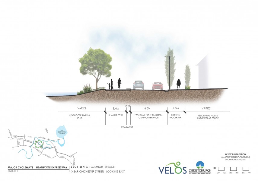
  • Shared Path: A 3.4m wide shared pedestrian and cycle path is proposed on the north side of Cumnor Terrace.
  • Parking: On street parking needs to be removed along both sides of Cumnor Terrace, with the exception of three parks outside Radley Park.
  • Trees: 7 trees and shrubs will need to be removed. Threshold: A small space where people can relax will be provided.
 Artists Impression

Click to enlarge.

Cumnor Terrace (Marshall Street)

 Key features of the proposed cycleway on this section of Cumnor Terrace

Click to enlarge.

Key features of the proposed cycleway on this section of Cumnor Terrace (Marshall Street):

  • Shared Path: A 3.4m wide separated shared pedestrian and cycle path is proposed on the north side of Cumnor Terrace.
  • Parking: On street parking will need to be removed along the north side of Cumnor Terrace.
  • Trees: 8 trees and shrubs will need to be removed.
 Before and after

Click to enlarge.

Cumnor Terrace (Garlands Road)

Key features of the proposed cycleway on this section of Cumnor Terrace

Click to enlarge.

Key features of the proposed cycleway on this section of Cumnor Terrace (Garlands Road):

  • Shared Path: A 3m wide shared pedestrian and cycle path is proposed on the north side of Cumnor Terrace.
  • Parking: On-street parking will need to be removed along the north side of Cumnor Terrace.
  • Crossing: A new signalised crossing will allow pedestrians and cyclists to safely cross Garlands Road.
  • Banned turns from south: The turn restriction from Cumnor Street south will remain in place.
  • Banned turns from north: A new central island will mean vehicles will not be able to turn right into or out of Cumnor Terrace.
  • Threshold: A small space where people can relax will be provided.
  • Trees: 6 trees and shrubs will need to be removed.

At the Cumnor Terrace/Garlands Road intersection vehicles will not be able to turn right into or out of Cumnor Terrace north.

Along Cumnor Terrace, between Sheldon Street and Garlands Road, on-street parking will be removed along the north side of the road, reducing the parking by approximately 50%.

Cumnor Terrace

 Key features of the proposed cycleway on this section of Cumnor Terrace

Click to enlarge.

Key features of the proposed cycleway on this section of Cumnor Terrace:

  • Shared Path: A 3m wide shared pedestrian and cycle path is proposed on the north side of Cumnor Terrace.
  • Parking: The existing angled on street parking will be changed to parallel parks.
  • Bridge: Separate to the cycleway project a new pedestrian bridge is proposed across the Heathcote River.
Artists Impression

Click to enlarge.

Cumnor Terrace (Maunsell Street)


 Key features of the proposed cycleway on this section of Cumnor Terrace

Click to enlarge.

Key features of the proposed cycleway on this section of Cumnor Terrace:

  • Shared Path: A 3m wide shared pedestrian and cycle path is proposed on the north side of Cumnor Terrace.
  • Parking: The existing angled on street parking will be changed to parallel parks.
  • Threshold: A small space where people can relax will be provided.


Between Garlands Road and Maunsell Street, the existing angled on-street parking will be changed to parallel parks. Parks will also need to be removed where a proposed new pedestrian bridge is to be built, separate to the cycleway project, across Heathcote River. This will reduce the parking by approximately 45%.


Cumnor Terrace - Kennaway Park

Cumnor Terrace

 Key features of the proposed cycleway on this section of Cumnor Terrace

Click to enlarge.

Key features of the proposed cycleway on this section of Cumnor Terrace:

  • Shared Path: A 3m wide shared pedestrian and cyclepath is proposed on the north side of Cumnor Terrace. The existing footpath on the south side will be removed.
  • Parking: Parking restrictions along this section of Cumnor Terrace will remain in place.
  • Driveways: Driveways will be widened where required so heavy vehicles can turn in and out from the narrowed road.

Cumnor Terrace

Key features of the proposed cycleway on this section of Cumnor Terrace

Click to enlarge.

Key features of the proposed cycleway on this section of Cumnor Terrace:

  • Shared Path: A 3m wide shared pedestrian and cyclepath is proposed on the north side of Cumnor Terrace. The existing footpath on the south side will be removed.
  • Parking: Parking restrictions along this section of Cumnor Terrace will remain in place.
  • Driveways: Driveways will be widened where required so heavy vehicles can turn in and out from the narrowed road.
  • Threshold: A small space where people can relax will be provided.

Cumnor Terrace (Chapmans Road)

 Key features of the proposed cycleway on this section of Cumnor Terrace

Click to enlarge.

Key features of the proposed cycleway on this section of Cumnor Terrace (Chapmans Road):

  • Shared Path: A 3m wide shared pedestrian and cycle path is proposed on the north side of Cumnor Terrace.
  • Shared Path: At Chapmans Road the path will continue along the edge of the river and widen to 4m.
  • Parking: On-street parking will be removed along the north side of Cumnor Terrace. Existing parking restrictions will remain on the south side.
  • Threshold: A small space where people can relax will be provided.

Kennaway Park

Key features of the proposed cycleway on this section of Kennaway Park

Click to enlarge.

Key features of the proposed cycleway on this section of Kennaway Park:

  • Shared Path: A 4m wide shared pedestrian and cycle path will follow the Heathcote River up until Kennaway Park.
  • Kennaway Park Construction Access: Cyclists and pedestrians will give way to vehicles using the construction road to Kennaway Park.

Two Eucalyptus trees which are in poor condition will be removed.

Kennaway Park - SH74 Tunnel Road – Main South Rail Line

Kennaway Park

 Key features of the proposed cycleway on this section of Kennaway Park

Click to enlarge.

Key features of the proposed cycleway on this section of Kennaway Park:

  • Shared Path: A 4m wide shared pedestrian and cycle path will continue through the Kennaway Park alongside stormwater areas swales.

Swales are shallow and only contain water after periods of rain.

Kennaway Road


 Key features of the proposed cycleway on this section of Kennaway Park

Click to enlarge.

Key features of the proposed cycleway on this section of Kennaway Park adjacent to Kennaway Road:

  • Shared Path: A 4m wide shared pedestrian and cycle path will continue to Kennaway Road.
  • Crossing: A new island will be built to allow cyclists and pedestrians to cross Kennaway Road.
  • Bridge/Culvert: A small bridge or culvert will be built across the drain.

SH74 Tunnel Road

 Key features of the proposed cycleway on this section of SH74 Tunnel Road

Click to enlarge.

Key features of the proposed cycleway on this section of SH74 Tunnel Road:

  • Shared Path: A 4m wide shared pedestrian and cycle path is proposed along the existing berm area of State Highway 74 Tunnel Road.
  • Barrier: A wire rope will provide a barrier between the road and path.

SH74 Tunnel Road

Key features of the proposed cycleway on this section of Tunnel Road

Click to enlarge.

Key features of the proposed cycleway on this section of Tunnel Road:

  • Shared Path: A 4m wide shared pedestrian and cycle path is proposed along the existing berm area of State Highway 74 Tunnel Road.
  • Barrier: A wire rope will provide a safety barrier between the road and path.
 Key features of the proposed cycleway on this section of Tunnel Road

Click to enlarge.

SH74 Tunnel Road – Main South Rail Line

 Key features of the proposed cycleway on this section of SH74 Tunnel Road

Click to enlarge.

Key features of the proposed cycleway on this section of SH74 Tunnel Road – Main South Rail Line:

  • Shared Path: A 4m wide shared pedestrian and cycle path is proposed along the existing berm area of State Highway 74 Tunnel Road.
  • Bridge: A new bridge will be built across the drain.
  • Tunnel Road Bridge: The path will follow the rail line, extending along the grass berm area under the existing Tunnel Road Bridge.

Main South Rail Line (Scruttons Road)

 Key features of the proposed cycleway on this section of Main South Rail Line

Click to enlarge.

Key features of the proposed cycleway on this section of Main South Rail Line (Scruttons Road):

  • Shared Path: A 4m wide shared pedestrian and cycle path is proposed along the existing access path next to rail line/ rail reserve.
  • Crossing: At Scruttons Road a raised platform will slow vehicle speeds. Pedestrians and cyclists give way to Scruttons Road traffic.
 Key features of the proposed cycleway on this section of Main South Rail Line

Click to enlarge.

Main South Rail Line - Truscotts Road (Martindales Road)

Main South Rail Line (Ferrymead Rail Line)

 Key features of the proposed cycleway on this section of Main South Rail Line

Click to enlarge.

Key features of the proposed cycleway on this section of Main South Rail Line (Ferrymead Rail Line):

  • Shared Path: A 4m wide shared pedestrian and cycle path adjacent to the rail line and Ferrymead Heritage Park is proposed.
  • Crossing: The railway line is only used on occasion by Ferrymead Heritage Park. Signs will warn users to look for trains. Gates will close off the line when it is not in use.
  • Trees: Seven trees will need to be removed.

This rail line is only used on occasion by Ferrymead Heritage Park. On the few occasions where it is used cyclists will be asked to wait behind the gates for a few minutes.

Main South Rail Line

 Key features of the proposed cycleway on this section of Main South Rail Line

Click to enlarge.

Key features of the proposed cycleway on this section of Main South Rail Line:

  • Shared Path: A 4m wide shared pedestrian and cycle path adjacent to the rail line and Ferrymead Heritage Park is proposed.

Main South Rail Line

 Key features of the proposed cycleway on this  section of Main South Rail Line

Click to enlarge.

Key features of the proposed cycleway on this section of Main South Rail Line:

  • Shared Path: A 3m to 4m wide shared pedestrian andcycle path adjacent to the rail line and Ferrymead Heritage Park is proposed.

Truscotts Road

 Key features of the proposed cycleway on this section of Truscotts Road

Click to enlarge.

Key features of the proposed cycleway on this section of Truscotts Road:

  • Share the Road: Cyclists will share the road with general road traffic along Truscotts Road. Road markings will indicate to drivers that this is a shared space.
  • Speed Limit: A 30km/hr speed limit will provide a safer environment for people to travel by bike.
  • Raised Platform: At Truscotts Road a raised platform will reinforce the slow speed environment.
  • New Footpath: On the north side of Truscotts Road a new footpath will connect pedestrians from the new shared path to the existing foothpath on Deavoll Place.
  • Trees: Trees will planted at suitable locations along the road.
  • Threshold: A small space where people can relax will be provided.

Along Truscotts Road where vehicles will share the road with cyclists, parking will be reduced where traffic calming measures are proposed such as raised platforms and near intersections.

Truscotts Road (Deavoll Place)

 Key features of the proposed cycleway on this section of Truscotts Rd

Click to enlarge.

Key features of the proposed cycleway on this section of Truscotts Road (Deavoll Place):

  • Share the Road: Cyclists will share the road with general road traffic along Truscotts Road. Road markings will indicate to drivers that this is a shared space.
  • Speed Limit: A 30km/hr speed limit will provide a safer environment for people to travel by bike.
  • Raised Platform: Deavoll Place will be realigned and the intersection will include a raised platform to reinforce the slow speed environment on Truscotts Road.
 Key features of the proposed cycleway on this section of Truscotts Road

Click to enlarge.

Truscotts Road (Martindales Road)

 Key features of the proposed cycleway on this section of Truscotts Road

Click to enlarge.

  • Share the Road: Cyclists will share the road with general road traffic on Truscotts Road. Road markings will indicate to drivers that this is a shared space.
  • Speed Limit: A 30km/hr speed limit will provide a safer environment for people to travel by bike.
  • Raised Platform: A raised platform will reinforce the slow speed environment on Truscotts Road.
  • Station Road: A path will connect cyclists from Martindales Road to Station Road.
  • Threshold: A small space where people can relax will be provided.

Give your feedback

Feedback on the plans for Heathcote to the Central City through Opawa, Woolston and Waltham closed 12pm Friday 23 December 2016.