|

Amatola Hiking
Trail
The Amatola Hiking Trail lies in the
Eastern Cape Province. It starts close to King Williams Town and ends at Hogsback. The
trail traverses some of the most breathtaking mountain scenery to be found in Southern
Africa. What makes this trail very special is the abundance of waterfalls and mountain
pools in which the hiker can cool off in and also the spectacular indigenous forests. The
trail is just over 100Km long and takes 6 days to accomplish.
Day 1- Maden Dam to
Gwiligwili Hut
 |
| The start of the
trail at Maden Dam |
|
|
From the starting point of the
trail the trail skirts the dam for a while before beginning the ascent through the rich
indigenous Pirie forests where once Yellowwood trees were harvested for rail transport.
Several relics from this bygone era still exist and can be seen as the hiker progresses
along the trail. |
|
|
|
The forest is rich in flora and
fauna. The hiker will come across incredible wormhills and upon investigation the worms
that made the mounds are equally impressive. The worm casts can make the path
slippery in wet conditions. As you climb through the forest it is worth giving a thought
to the wood cutters of long ago as they spent their whole lives in these ancient forests.
The fungi found in the forest are
also rich in variety and colours. |
|
 |
 |
| A lovely Treefern |
Giant earth worm |
|
|
|
|
 |
 |
| Gwiligwili
Hut |
|
|
Gwiligwili hut is situated on a
hillside with beautiful view down into the valley bellow and provides a comfortable nights
rest after a hard days hiking. |
|
|
|
Day 2 - Gwiligwili
Hut to Dontsa Hut
Day 2 of the Amatola Trail is
the longest section of the trail. For much of the day the trail follows a ridge
overlooking the Keiskammahoek valley. It is important to make an early start for this
section of the trail as it is nice to arrive at the Dontsa Hut in time to explore the
nearby waterfall. |
|
 |
| View after leaving
Gwili |
|
|
|
|
 |
| The start at Dontsa
Forest Station |
|
|
Although the full Amatola trail
is 6 days long, it is possible to do shorter sections of it. A popular option with hikers
is to join the trail at Dontsa Forest Station, thereby cutting out the first 2 days of the
trail. This should be avoided if possible as, especially, the first days walk through the
forests is well worth the effort. |
|
|
|
After a long day of hiking,
Dontsa Hut is a welcome sight. Sitting and relaxing by the open fire, the stresses and
cares of city life seem a million miles away. Already relaxation has taken over and the
only cares are physical well being. |
|
 |
| Settling in at
Dontsa Hut |
|
|
|
|
Day 3 - Dontsa Hut
to Cata Hut
 |
| First waterfall of
the day |
|
|
The third day of the Amatola
trail is also a long day so it is important to make an early start. Leaving the forest
behind, the trail ascends to the plateau, where macchia grassland and a myriad of
wildflowers contrast startlingly to the richness of the verdant forest below. |
|
|
|
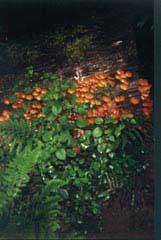
Along the way one can find
examples of several different types of Fungi (edible and inedible). The one illustrated is
an edible one and we were able to enjoy a meal of them when we arrived at Cata. One needs
to be very certain that what one is eating is an edible type. We were fortunate enough to
be guided in this respect by the forester. |
|
 |
| An
edible mushroom |
|
|
|
|
 |
| Mountain views on
the way to Cata |
|
|
The day is long and exhausting
but the amazing scenery make it all worth while. What makes this trail very special is the
diversity. The forests, the mountains, the waterfalls and the flora all go to make this
trail unique among trails in Southern Africa. |
|
|
|
The last part of the day's trail
traverses through the Waterfall forest before a final ascent up a revine to Cata Hut. The
Amatola Trail is sometimes known as the waterfall trail and this is an apt description of
this hike. |
|
 |
| Beautiful waterfall
near Cata |
|
|
|
|
 |
 |
| Old Cata Hut in snow |
The new Cata Hut |
|
|
The new Cata Hut is spacious and
comfortable. Take the opportunity to have a good nights rest as the fourth day is quite a
difficult day. |
|
|
|
Day 4 - Cata Hut to
Mnyameni Hut
 |
| Geju Peak |
|
|
From Cata Hut, the trail ascends
steeply towards Geju peak (1850m), one of the higest points on the trail. From this
vantage point, the hiker can look out over the whole Keiskammahoek river basin, Gaika's
Kop, Elandsberg, Hangklip (at Queenstown) and all the way to the Indian Ocean. Hikers can
byepass Geju as there is an alternative route that should be taken when the peak is
covered in mist but it is well worth the effort to ascend to the top if one is able. |
|
|
|
From Geju Peak the trail
descends steeply, passing over some scree slopes until one reaches the top of the Mnyameni
gorge. The rest of the day is spent climbing down through this amazing gorge, passing
numerous magnificent waterfalls. |
|
 |
 |
| Fault Falls |
Another of the Falls |
|
|
|
|
 |
 |
| More
beautiful waterfalls |
|
|
As soon as one passes one
beautiful waterfall another equally beautiful falls soon comes into view. The Amatola, not
without reason, is sometimes called the waterfall trail. The abundance of water on the
trail is one of the main reasons that many hikers consider this trail to be the top inland
trail in South Africa. |
|
|
|
Mnyameni Hut is the remotest of
all the huts on the Amatola Trail. It is a thatched hut set in the shadows of the Hogsback
mountains. |
|
 |
 |
| View from inside the hut |
Outside view of Mnyameni Hut |
|
|
|
|
Day 5 - Mnyameni Hut
to Zingcuka Hut
 |
| After Leaving Mnyameni |
|
|
From Mnyameni Hut the trail
climbs steeply, firstly through indigenous forest and then though grassland, along an
exciting path that leads along a ridge behind the tallest of the Hogsback peaks.
Eventually the trail crosses over the ridge into the Wolf river valley. Keep a lookout for
Falcons and other birds of prey while descending though this beautiful valley. As the
fourth day of the trail is known for its waterfalls so this day is known for its beautiful
cascade of pools to swim
in.. |
This is the day that one needs
to leave time for messing around in the water. Pool after pool extends to the hiker an
invitation to come and swim. |
|
 |
 |
| Lovely
pools of water |
|
|
|
|
|
|
Pool after pool of crystal clear water. The area
is renowned for its Trout. Many people liken the streams to those of Scotland. |
|
|
|
The trail follows a cliff edge
for some distance before a steep descent through a gap in the rocks and down the
"Razor Edge". The final part of the day's walk is through dense indigenous forest
which can be very dark under overcast conditions.
It should be noted that weather
conditions in the area are unpredictable. Once when we did the trail we
incurred a
heat wave, heavy rain, snow and gales all in one period during April. |
|
 |
| Indigenous Forest |
|
|
|
|
 |
| Zingcuka Hut |
|
|
Zingcuka Hut is a beautiful
wooden hut with comfortable beds, a "Donkey" boiler to heat the water, and
tables and chairs to sit around. The hut also has samples of different woods that are
found in the local forests. The trail can be terminated at this point but the final day of
the trail is worth the effort to do if one has the time. |
|
|
|
Day 6 - Zingcuka to
Tyume River and Hogsback Village
The final day of the Amatola
trail start with a walk through the delightfully cool Zingcuka idigenous forest. Another
impressive waterfall is passed and from the top of the falls impressive views of the
Amatola basin can be seen. The trail continues to ascend up Hogsback peak. From the top,
views of Hogsback and the entire Tyume river basin lie sprawled out below. Finally the
trail descends to Hogsback and the end of the trail.
Along the trail
you may find examples of the original Blue Crane markers. These were the emblem of the
original rulers when the trail fell under the former Ciskei |
|
 |
| An
original trail marker |
|
|
|
|
|
|
Conclusion
The Amatola deservedly has been
described as one of the top hiking trails in South Africa. It is not an easy trail but the
effort needed to do it is well worth it. Due to its nature and the
unpredictable weather
conditions it is important to prepare properly for it. Novices should not attempt to do
the trail without an experienced hiker to lead them. The days are generally long and an
early start is always advisable. |
|
|
|
The Amatola Hiking trail is book able through
Department of Water
Affairs and Forestry
Telephone +27 43 642
2571 Fax +27 43 604 5529
e-mail
Amatolhk@daff.gov.za
Postal address
Private Bag X7485 King William's Town 5601
Accommodation before
and/or after the hike can be arranged through
Amatola Mountain
View Guest House, King William's Town
Telephone/Fax +27 43
642 1747 e-mail pat@amatola.co.za,
www.amatola.co.za
or in Hogsback
The Edge Self
Catering Accommodation
Tel/Fax +27 45 962
1159 e-mail theedge@execunet.co.za
www.hogsback.co.za/accommodation/the_edge.htm
Transport to the
beginning of the trail can also be arranged through the above
Footprint Hiking Club
To view other pages on
our website, click on a hyperlink below
|